I was supposed to go to a day camp with three other SAR members, to help teach kids ranging in age from five to 12 how to use a compass, what makes a "good pack" versus a "bad pack" (that is, gear you should bring on a hike versus stuff to leave at home), and how to not get lost or to "get found" if you do. We went to this summer camp last year, and our program was a hit with campers and camp leaders alike, so they'd asked us to come back.
And I was going to, until right before I was supposed to leave the house. That's when there was a call-out for a rescue, possibly technical the message said, in the Dorsey Springs area of Sycamore Canyon.
So, per the request of the deputy coordinating the mission, I bailed on my teammates going to the camp and responded to the rescue instead.
Late the night before, there had been a call-out for the search for this 41-year-old overdue hiker who now needed rescue. I hadn't responded to that call because of my prior commitment to the camp program in the morning. Apparently, this man was at least a day overdue when a concerned family member had reported him missing, and his vehicle had been located by deputies at the Dorsey Springs trailhead. Just after dawn, searchers had found him down in the canyon, severely dehydrated, weak, and disoriented.
By the time those of us responding to the rescue call later that morning arrived at the trailhead, the hiker had been hydrated and slowly walked with aid partway up the trail. At that point, the man said he couldn't walk anymore. The two deputies who were with him requested assistance and more water. Several of us hiked in with supplies to meet up with them.
When we arrived, the man was sitting under a tree. He drank some Gatorade and spoke to one of our teammates, who's a paramedic. The man said he was okay except for being dehydrated and clearly explained what had happened over the past several days. The searchers who'd found first his backpack and then, maybe a few hundred yards away, the subject filled us in on his state of mind and actions at the time he was located. He'd made quite an improvement after having something to drink and eat.
Sadly, the two dogs he'd brought on the multi-day hike—adult, black-colored boxers, a male and a female—were nowhere to be found. They'd stopped following him at least a day and a half earlier and laid down in the shade. Had they had enough left in them to find their way back to the last water source they'd been at with the man? I hoped they had. And that they'd survive long enough for someone to find them. I was preoccupied by those thoughts as I watched the short-haul procedure, when the man was air-lifted to the trailhead. He refused medical transport by the waiting ambulance.
Lessons for the day: Carry a lot of water if hiking in hot desert canyons during the summer. Hike early and hike late, and rest in the shade during the day. Know where the water sources are, and make sure they currently have water in them. Call the Forest Service or whichever agency oversees the area and check on those sources. For Sycamore Canyon, that would be:
Coconino Forest Supervisor's Office
1824 S. Thompson St.
Flagstaff, AZ 86001
(928) 527-3600
Fax: (928) 527-3620
Update: I've been told that one of the two dogs that had been lost in the canyon has been located alive and returned home. The other has not been found yet. So keep an eye out if you're down there!

These are my stories as a volunteer member of the Sheriff's Search and Rescue team in Coconino County, Arizona. I'll share what it's like to go from a beginner with a lot to learn to an experienced and, hopefully, valuable member of the team, as well as the missions, training, and other activities along the way.
Showing posts with label Canyon Search. Show all posts
Showing posts with label Canyon Search. Show all posts
A Remote Canyon Search
 |
This was my third day on what had been, so far, a week-long search for an overdue and very experienced canyon hiker. Today was his 66th birthday, and I was hoping to wish him a happy one... or that someone else would, at least.
Was he out here somewhere in this vast, rugged, incredibly beautiful landscape of colorful rock layers, cactus and cliffs? If anyone could survive out here, he could. But for how long? Or was he long gone maybe, alive and well outside of the area? Lots of scenarios had passed through my mind and in the minds of other searchers over the past week.
My teammate broke through my thoughts and the silence.
"You can search the inner part," he said. "I'll go out near the edge." He knows I'm not fond of edges when I'm not on a rope.
We both hoisted our packs, heavy with water, and began walking slowly among the cactus and desert brush, studying the ground and stopping frequently to look around for anything that didn't look "usual"—an out-of-place color that might catch our eye, bird activity. Any kind of sign that another person had passed through the area. We were also listening and looking carefully for rattlesnakes. Both "pinks" and "greens," the latter being the very deadly Mohave rattlesnake, had been seen (and heard) during this search.
These were some of the most difficult tracking conditions I'd encountered during my years in SAR, not just the rocky and coarse, sandy substrate but the fact that wild horses and other critters had tramped all over the place, including here, along the bottom of the canyon where I'd searched two days earlier, and on the Esplanade where I'd searched two days before that. Add the age of some of the tracks we had encountered, and I really had to go slow, look around at the same spots from different angles, and get down on hands and knees at times. My teammate and I occasionally consulted with one another: "Is that a footprint or a hoof print?" Sometimes, in some conditions, it's hard to tell.
We searched our canyon island from end to end, looking carefully at the "pinch-points" to the north and south where someone would have to have walked in order to get around the side canyons, the heads of which left little room to negotiate the drop-offs.
No signs of human prints or other evidence.
We took a break in the shade of a large overhang, careful to check there too before sitting down, in case someone else had also taken respite in that cool, cozy nook. But again, nothing.
We watched a single, circling vulture, but the bird soon moved on and circled somewhere else.
And we found nothing more before the helicopter came back for another sandblasting, to pick us up and fly us back to Incident Command, where we converged with other field teams. No one reported any new sign on this particular day.
But as far as I heard at the last general SAR meeting, there is more searching to be done, to follow up on sign found by a Park Service employee who was helping with the mission. I'd seen him when he started off at the head of Mohawk Canyon, prepared to be out for as long as six days. He was one of several canyon experts who's assisted the Sheriff's Office and our team with this search.
Want to read more about this mission and who we're searching for? See...
Hiker on Hualapai Reservation Missing
Missing Hiker a Canyon Expert
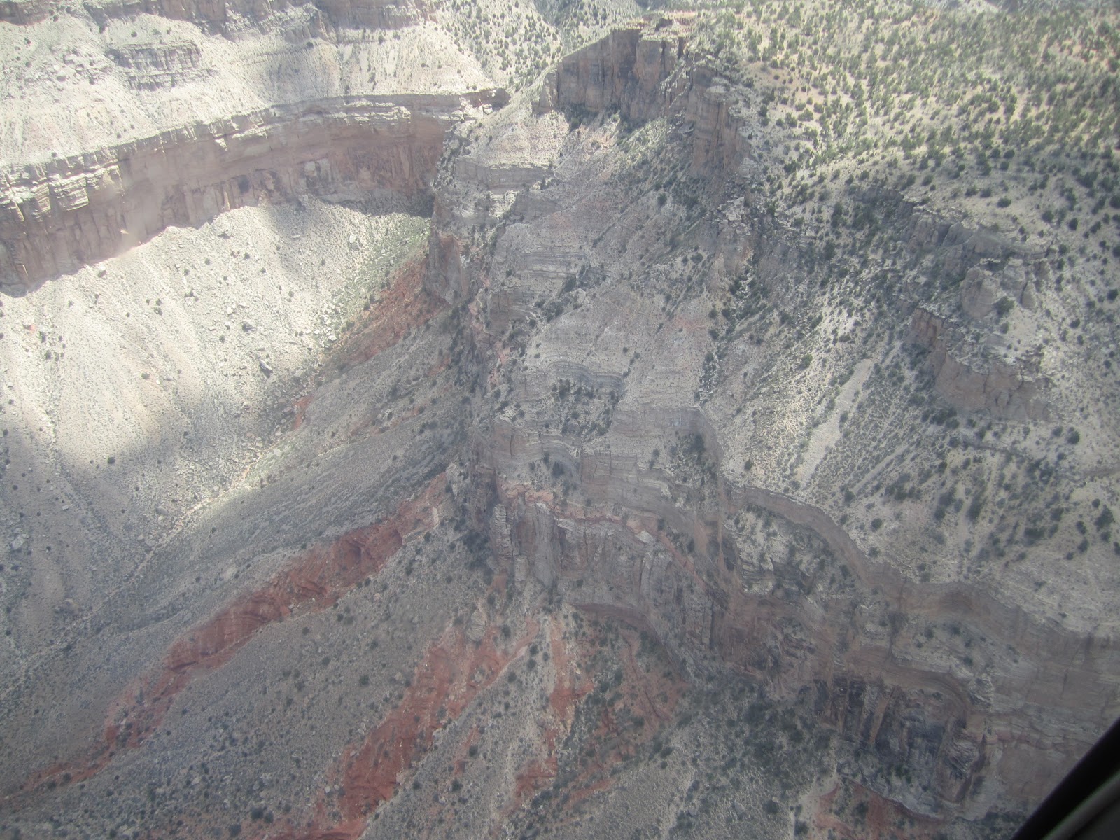 |
| A bird's-eye view from the helicopter |

 |
| On the Esplanade on my second day as part of this search |
 |
| My teammate, Steve, searches on the Esplanade. |
Searching for Justin

With my left set of fingertips gripping a tiny, sharp ridge of (hopefully) embedded volcanic rock above me, my left foot perched on a small piece of (hopefully) embedded rock below, and my free hand and foot groping for something solid, I tentatively glanced down over my left shoulder. I decided there was no way I could safely go back the way I'd just come up, and I was doubtful about moving on.
The steep wall of the canyon was covered in loose cinder, and I couldn't know for sure if the pieces of rock I wasn't quite able to reach were loose or solidly attached. Judge incorrectly or make a wrong move, and I was going for a fast ride down that cinder slide and over that ledge down there. That's what I was envisioning, anyway.
Crap. Not the kind of pickle I want to find myself in. And my two more confident teammates knew it. Every other word of mine was a bad one at that point.
So, you see, we'd completed our assignment, having been inserted into the Little Colorado River gorge by helicopter several hours earlier, exiting the DPS aircraft as the rotors continued to spin and kick up sand. We'd searched the far side of the river, which was flowing pretty well at the time, overlapping the point where another team had been inserted further upstream.
We then forded the river at a wide, shallow (and slippery) area, and searched the opposite bank back the way we'd come. We'd been careful to look at piles of river debris from past flooding and kept an eye on the mud and shallow parts of the river for anything unusual that might be sticking out. We'd searched the shores, including small caves and crevices and vegetation that could potentially catch and hide human remains.


We were looking for any sign of 40-year-old Justin Brian Hall, an avid outdoorsman, former Appalachian Trail thru-hiker, and climber, who'd disappeared from a friend's home where he'd been house-sitting in the very rural area near Sheba Crater and the border of the Navajo Reservation more than a month earlier.
This was a continuation of the ongoing search, which had already extensively covered a one-mile radius around the house and well beyond, following up on tips and suggestions from locals and Justin's family and friends. Nothing at all had turned up that would indicate a destination or direction of travel.
This is the house where Justin had been staying....

Now searching about 10 miles (as the crow flies) from Justin's last known location, where his vehicle and belongings remained, ground teams were covering several miles along the Little Colorado River. A K9 team, with me as one of the backers, had already searched the area just below and partway up Grand Falls at an earlier date, but it was being searched again on this day.
We were looking not only for human remains but possibly a couple of items believed to be in Justin's possession at the house but yet were unaccounted for, as well as any type of clue or sign that could potentially be linked to him. We found nothing.
Here are a couple of photos from our earlier search at Grand Falls with the dogs....

 |
| This is us searching partway up the falls, on a ledge. |
Today, by the time our field team of three returned to where we'd been dropped off at the bottom of the canyon several miles downstream from Grand Falls, the DPS crew had been reassigned and left the area. So, our options were to climb out on our own or... yeah, that was about it. We could do that either somewhere near where we were or turn around and hike all the way back to Grand Falls, where we knew there was a trail to the rim. Or perhaps find a good place to climb out along the way.
We chose to find a route near where we were, but, looking up, it was difficult to tell how it would go. For the most part, the climb turned out to be steep (obviously), and the rocks and sparse vegetation were sharp, but it was otherwise okay... except for a couple of spots, like the one I described above, where I was temporarily frozen. And stopping one's momentum in sketchy spots doesn't exactly help matters. I could feel myself slipping every second I stayed in place.
Thankfully, my teammates stationed themselves in spots below and above me, which gave me just enough confidence to move from those precarious locations. After anchoring himself as best he could, one of my companions offered me an outstretched wrist to reach for in case I needed it (which thankfully I didn't). My feet slipped as I practically threw myself across to the closest stable spot.
Eventually, the climb turned into a heart-pounding, steep scramble up a volcanic scree slope, but the scary stuff was over. Here's Keith at the top of the cinder slope....

Once at the top, we began walking toward base as we waited for someone to reach us by vehicle for a ride back.
********
Since that day about two weeks ago, the team hasn't been called upon again to search for Justin, who is still missing and very much missed by his family, many of whom are back east.And here are two photos of Grand Falls, the first one taken on the day I just described. It was running quite a bit more than it had been about 10 days earlier, when I'd gone there to search with the K9 team. The next photo was taken during spring runoff a few years ago. When Justin Hall went missing in mid-September, the Little Colorado was flowing at a much higher level than it was in the top photo but not as much as the lower...


Searching Under the Desert Sun
I was still searching, looking left and right and sometimes behind me because you can miss things on the backsides of boulders and other terrain features, but I also kept glancing ahead at that enticing little slice of shade in the distance, beneath the large rock overhang. I would head to that slice of shade and stop there for a good rest with the two men searching on either side of me. We all needed it.
I was feeling cooked—broiled, baked, sauteed, and steamed. The air temperature was at least 100 degrees, but the sun reflecting off the sand and rock made it feel even hotter, right through the soles of my boots. I wasn't sunburned, though; the sunblock I'd already reapplied twice was doing its job.
My water and blue Gatorade was hot, and I was now doing more of a shuffle than a walk. Walking in sand in that heat sure saps your energy.
So, have I mentioned it was hot? 🌞
We'd started searching our rather large segment a few hours earlier. We had plotted the UTM coordinates for the four corners of the assigned area then entered them into our GPSes, which were set up to record our tracks. Those tracks would later be downloaded by our coordinator onto his mapping software.
We drove up the highway to the southeast corner of our segment, spread out, and began an east-west grid search, walking about a mile with each pass. The canyon on the western edge of our segment required additional effort to search each time we came to that end. We could see fresh ATV tracks in the sand at the bottom of that canyon, which had been searched from below the day before.
This was the second day of SAR's involvement in the search, with two counties now participating, divided into several field teams. We'd met up at 4 a.m. to drive to the search area and get an early start because of the high desert temperatures. The sun was intense by 8:00. The K9 teams put special vests on their dogs that were soaked with water, and human searchers exchanged some gear for extra water bottles in their packs.
(In case you didn't know, it was hot!)

Shortly before I reached that coveted slice of shade, I overhead the K9 teams on the radio. They'd completed their assignment, and the dogs were spent. Incident Command offered rides back in the Polaris (UTV) for canines and handlers, and they readily accepted.
My search partners, both from Yavapai County, angled in toward my location, and the three of us dropped our packs in unison and ourselves into the shade. We'd completed about half our segment by 11 a.m. Another team reported that they too were taking a shade break before continuing to grid search their segment. We heard the lucky team on the river over the radio, doing their searching by boat and with a spotting scope. (But they deserved that assignment; both had been out here on foot and on ATVs the day before.)
After about 20 minutes of rest, my partners and I resumed our grid pattern, staying alert for the sound of rattling that could come from beneath any bit of brush or shaded bit of ground beneath a rock at any moment. We'd been told to watch out for rattlesnakes and scorpions, but no one reported encountering either one. I'm quite sure they were watching us, though.
Later that day, field teams converged back at base. The subject was (and as far as I know at this time, still is) missing. I can't give any details of the mission, I'm afraid, since it's an ongoing investigation, but I can point you to the brief missing person's report with the young man's photo: Police Search for Missing Page Man.
The search continued the following day, with members of our team's mounted unit responding.
And in other recent Coconino County SAR news...
Last week, I reported about the search in Grand Canyon for the overdue backpacker who'd begun his hike on the North Rim. I'm happy to say that the missing man was found on June 17th, tired and unable to each much but otherwise in good condition and good spirits.
Coco. SAR also recently responded to a call for the carry-out of a hiker who'd fractured her ankle near the saddle on the Humphreys Trail. Four search and rescue volunteers went up to Snowbowl (ski area), where a fire engine and an ambulance were already there. Two firemen and three personnel from Guardian had been deployed via a Snowbowl UTV up one of the ski runs to the base of a steep route that eventually connects with the Humphreys Trail at 11,400 feet. (We use this route as a shortcut when subjects are located near or beyond that elevation.)
Coconino County SAR drove our team's own UTV to the bottom of the route and then proceeded on foot. By that time, the firemen and medics were already with the subject. SAR made good time, and when they rendezvoused with the others, they tied the patient into the Stokes litter and carried her up the trail a ways until they found a relatively clear area to descend. They attached a 300-foot rope to the litter and slowly lowered the patient. It took four evolutions to get her down to the Polaris Ranger. She and two Guardian medics rode the UTV to the ambulance, while the rest walked down.
There was also a call-out to search for an overdue hiker in the Blue Ridge area, but SAR was turned around at Lake Mary when the subject turned up.
And last night at 7:45, while I was at a dinner party, there was another call-out for a litter carry near the saddle on the Humphreys Trail, for another patient with a fractured ankle.
I was feeling cooked—broiled, baked, sauteed, and steamed. The air temperature was at least 100 degrees, but the sun reflecting off the sand and rock made it feel even hotter, right through the soles of my boots. I wasn't sunburned, though; the sunblock I'd already reapplied twice was doing its job.
My water and blue Gatorade was hot, and I was now doing more of a shuffle than a walk. Walking in sand in that heat sure saps your energy.
So, have I mentioned it was hot? 🌞
 |
| Two members of Yavapai County SAR and I grid search in the desert. |
We'd started searching our rather large segment a few hours earlier. We had plotted the UTM coordinates for the four corners of the assigned area then entered them into our GPSes, which were set up to record our tracks. Those tracks would later be downloaded by our coordinator onto his mapping software.
We drove up the highway to the southeast corner of our segment, spread out, and began an east-west grid search, walking about a mile with each pass. The canyon on the western edge of our segment required additional effort to search each time we came to that end. We could see fresh ATV tracks in the sand at the bottom of that canyon, which had been searched from below the day before.
This was the second day of SAR's involvement in the search, with two counties now participating, divided into several field teams. We'd met up at 4 a.m. to drive to the search area and get an early start because of the high desert temperatures. The sun was intense by 8:00. The K9 teams put special vests on their dogs that were soaked with water, and human searchers exchanged some gear for extra water bottles in their packs.
(In case you didn't know, it was hot!)

Shortly before I reached that coveted slice of shade, I overhead the K9 teams on the radio. They'd completed their assignment, and the dogs were spent. Incident Command offered rides back in the Polaris (UTV) for canines and handlers, and they readily accepted.
My search partners, both from Yavapai County, angled in toward my location, and the three of us dropped our packs in unison and ourselves into the shade. We'd completed about half our segment by 11 a.m. Another team reported that they too were taking a shade break before continuing to grid search their segment. We heard the lucky team on the river over the radio, doing their searching by boat and with a spotting scope. (But they deserved that assignment; both had been out here on foot and on ATVs the day before.)
After about 20 minutes of rest, my partners and I resumed our grid pattern, staying alert for the sound of rattling that could come from beneath any bit of brush or shaded bit of ground beneath a rock at any moment. We'd been told to watch out for rattlesnakes and scorpions, but no one reported encountering either one. I'm quite sure they were watching us, though.
 |
| There were all sorts of nooks and crannies where rattlesnakes could be hanging out. |
Later that day, field teams converged back at base. The subject was (and as far as I know at this time, still is) missing. I can't give any details of the mission, I'm afraid, since it's an ongoing investigation, but I can point you to the brief missing person's report with the young man's photo: Police Search for Missing Page Man.
The search continued the following day, with members of our team's mounted unit responding.
And in other recent Coconino County SAR news...
Last week, I reported about the search in Grand Canyon for the overdue backpacker who'd begun his hike on the North Rim. I'm happy to say that the missing man was found on June 17th, tired and unable to each much but otherwise in good condition and good spirits.
Coco. SAR also recently responded to a call for the carry-out of a hiker who'd fractured her ankle near the saddle on the Humphreys Trail. Four search and rescue volunteers went up to Snowbowl (ski area), where a fire engine and an ambulance were already there. Two firemen and three personnel from Guardian had been deployed via a Snowbowl UTV up one of the ski runs to the base of a steep route that eventually connects with the Humphreys Trail at 11,400 feet. (We use this route as a shortcut when subjects are located near or beyond that elevation.)
Coconino County SAR drove our team's own UTV to the bottom of the route and then proceeded on foot. By that time, the firemen and medics were already with the subject. SAR made good time, and when they rendezvoused with the others, they tied the patient into the Stokes litter and carried her up the trail a ways until they found a relatively clear area to descend. They attached a 300-foot rope to the litter and slowly lowered the patient. It took four evolutions to get her down to the Polaris Ranger. She and two Guardian medics rode the UTV to the ambulance, while the rest walked down.
There was also a call-out to search for an overdue hiker in the Blue Ridge area, but SAR was turned around at Lake Mary when the subject turned up.
And last night at 7:45, while I was at a dinner party, there was another call-out for a litter carry near the saddle on the Humphreys Trail, for another patient with a fractured ankle.
Search for Overdue Backpacker on the North Rim, Grand Canyon
On Thursday, members of our Coconino County Search and Rescue team headed out to help the National Park Service with a search in the area of Sowats Point and Jumpup on the North Rim of the Grand Canyon. Volunteers were told they needed to be prepared to be self-sufficient for 48 hours.
I don't know a lot about the search at this time, except that the 64-year-old solo hiker was on a strenuous multi-day trip including the Bill Hall Trail and was due out of the canyon on Monday. After the Park Service was notified, presumably by family, that the hiker was overdue, they conducted some of their own investigation and searching before contacting Coconino SAR for assistance on Wednesday afternoon. I'm told that high winds have hampered aircraft searches in the area.
If the search continues beyond Saturday, I expect more requests for Coconino SAR's assistance. My backpack is always ready, just in case.
On June 8th, the team was called out to help with evacuations and road blocks associated with a wildfire in the Turkey Hills area east of Flagstaff. This turned out to be an intentionally set fire—make that fires because there were 14 of them (!) along a gas pipeline—which forced the evacuation of approximately 50 area residents and burned an unoccupied mobile home. Thankfully, no one was hurt, and the fire was quickly contained by several ground crews and air tankers.
As the firefighting efforts were underway, a woman approached one of our team members at a road block. Visibly upset, she spoke to the SAR volunteer for several minutes, then admitted she was concerned that a family member had started the fires. Information was taken from the individual, and then SAR contacted the Sheriff's Office.
In the early hours of June 9th, 20-year-old Obrian Wilson Kee was arrested and eventually admitted to starting the fires because he was upset with his girlfriend. See: Arrest Made in Hill Fire from the Arizona Daily Sun.
SAR also recently responded to three calls for lost or overdue hikers on the same day. All were quickly located and in good condition.
We have a feeling this is going to continue to be a busy summer for Coconino County Search and Rescue, in part because Arizona's White Mountains have been torched by the Wallow Fire, likely bringing even more people to the northern part of the state for outdoor recreation.
I don't know a lot about the search at this time, except that the 64-year-old solo hiker was on a strenuous multi-day trip including the Bill Hall Trail and was due out of the canyon on Monday. After the Park Service was notified, presumably by family, that the hiker was overdue, they conducted some of their own investigation and searching before contacting Coconino SAR for assistance on Wednesday afternoon. I'm told that high winds have hampered aircraft searches in the area.
If the search continues beyond Saturday, I expect more requests for Coconino SAR's assistance. My backpack is always ready, just in case.
******
In other Coco SAR news...On June 8th, the team was called out to help with evacuations and road blocks associated with a wildfire in the Turkey Hills area east of Flagstaff. This turned out to be an intentionally set fire—make that fires because there were 14 of them (!) along a gas pipeline—which forced the evacuation of approximately 50 area residents and burned an unoccupied mobile home. Thankfully, no one was hurt, and the fire was quickly contained by several ground crews and air tankers.
As the firefighting efforts were underway, a woman approached one of our team members at a road block. Visibly upset, she spoke to the SAR volunteer for several minutes, then admitted she was concerned that a family member had started the fires. Information was taken from the individual, and then SAR contacted the Sheriff's Office.
In the early hours of June 9th, 20-year-old Obrian Wilson Kee was arrested and eventually admitted to starting the fires because he was upset with his girlfriend. See: Arrest Made in Hill Fire from the Arizona Daily Sun.
SAR also recently responded to three calls for lost or overdue hikers on the same day. All were quickly located and in good condition.
We have a feeling this is going to continue to be a busy summer for Coconino County Search and Rescue, in part because Arizona's White Mountains have been torched by the Wallow Fire, likely bringing even more people to the northern part of the state for outdoor recreation.
Congratulations Are in Order
Recently, at both the Arizona State Search & Rescue Conference and last night's Coconino County Board of Supervisors meeting here in Flagstaff, our coordinator, Sergeant Aaron Dick, and long-time volunteer Dennis Gill were both honored for their excellent work with the team. Aaron was awarded Arizona SAR Coordinator of the Year, and Dennis, who's been with the team for 25 years, was given the award for Arizona SAR Volunteer of the Year.

That's Aaron on the left, behind the lady in purple, and Dennis on the right.
Many of our team members showed up to support Aaron and Dennis, wearing our uniform shirts. Half the room was a sea of yellow.

And there's Beverly, sneaking in behind the Board of Supervisors to take pictures as Sheriff Bill Pribil presents Aaron with his plaque.
I know the whole team was proud of our leader and of Dennis's many years of volunteer service. They're both so great at what they do and totally deserve the recognition. Congratulations, guys!
And as far as recent call-outs go...
On Monday morning, the team began a search in the area of Sycamore Canyon for two overdue hikers, who'd intended to go for a day hike on Saturday. The team had fanned out to first search for their Jeep because the reporting party, the wife of one of the hikers, was unsure of their exact destination.
Our plan was that, once the subjects' vehicle was located, that team would begin a hasty search on foot. But the two subjects were able to make a cellphone call to the reporting party before we found their Jeep. They emerged uninjured from the canyon a short time later, having been lost for 48 hours without cell service. See: Overdue Hikers Emerge Unscathed.
This morning, there was a call regarding two overdue hunters, but they too showed up as SAR was en route.
A Grand Canyon Search Is Over
Here's the latest news release from Grand Canyon National Park about the search for Andrew Brunelli of North Carolina: Body Believed to be that of Andrew Brunelli Found
I send my deepest condolences to Mr. Brunelli's family and friends. As always, I wish the ending to this story had been a happy one.
I send my deepest condolences to Mr. Brunelli's family and friends. As always, I wish the ending to this story had been a happy one.
******
Well, I'm off to tidy up my SAR pack, then attend the second evening of this year's new-member academy with my husband, who's joining the team. I'm going to help out with some of the classes, but sitting in on the rest never hurts. I always learn something new and refresh my memory on everything else. We have a big group this time, with around 30 new recruits attending.A Grand Canyon SAR
 I'm back home now after a day and a half at Grand Canyon, helping with an ongoing SAR mission. As I type, I'm listening to the live audio feed from the Canyon, trying to keep tabs on the search for 43-year-old Anthony Brunelli of North Carolina (pictured here), who's been missing since Monday, August 31, when he was last seen at the South Rim entrance around 5 a.m. His rental car was later found at the Grandview trailhead, which is east of Grand Canyon Village and the South Kaibab Trail.
On Sunday, four of us from Coconino County SAR headed to Grand Canyon where, after a 6 a.m. briefing, we were given our assignments and joined the search, which had already begun. Each of us was assigned a team leader and inserted by helicopter into various locations in the relative vicinity of the Grandview Trail and Horseshoe Mesa, though often miles away. We'd work our way back toward that area as we searched.
This was quite an adventure for me, not only seeing how SAR at Grand Canyon operates but also getting my first helicopter rides in and out of that awesome place. I also saw part of the canyon I'd not been to before, including Grapevine Canyon and the six miles of the Tonto Trail between there and Cottonwood drainage, parts of which are right along the edge of a very long way down.
I was assigned to work with a volunteer member of Coconino County SAR who also happens to be a park ranger. He was great company and very supportive when I admitted my anxiety—not that I could have hidden it—about the exposure along the Tonto Trail. We played some fun (okay, sorta silly but effective) memory and word games as we hiked along those stretches, which helped me focus on my brain rather than my fear, though I kept close watch on the trail and took careful steps. Having tripped over my own trekking poles in the past, I didn't want that to happen there.
The scenery, though, was just incredible, which I couldn't help but marvel at as we searched. My partner and I made our way up both forks of narrow Grapevine Canyon and then searched Grapevine in the other direction, toward the Colorado River, until the route became too technical to proceed without ropes.
Once we were finished with that part of our assignment, we took a break in the shade as the temperature in the sun topped 100 degrees. But we decided to proceed onto the Tonto Trail midday, as some cloud cover eventually helped mitigate the heat. We each had over a gallon of water left to make the trek to our intended campsite and the water cache back at the Cottonwood drainage, so we both were comfortable with continuing then rather than waiting till late afternoon.
As we hiked, we both looked up and down washes and scanned the area for any sign of... well, anything unusual, including a bit of color that didn't fit or increased bird activity. And I periodically stopped and looked behind me for a different view of what we'd just passed, not wanting to miss anything. As of late afternoon, when we reached Cottonwood Creek at the cache, we hadn't located any clues.
After staying the night at Cottonwood drainage with two other search teams who'd converged there, while others camped in different areas around and on Horseshoe Mesa, most of us were extracted by helicopter the next morning and exchanged with fresh teams. One of my CoCo SAR teammates, also a Grand Canyon PSAR volunteer, was reassigned to work with K-9 teams brought in from another county, while the rest of us debriefed and then headed back to Flagstaff. We were willing to stay on and continue to help, but the park had enough personnel to handle things at that point.
For more information on the search, see the National Park's latest News Release at The Search for Andrew Brunelli Continues in Grand Canyon National Park
Young Hiker Missing In Grand Canyon
Yesterday, a news release was put out by Grand Canyon National Park regarding possibly as many as four missing hikers. Last I heard, technical rescue personnel were en route, some from Zion National Park, possibly to be inserted by helicopter into a remote and rugged area.
The news from 7/22 release begins:
Grand Canyon, Ariz. – At approximately 7:20 p.m. on Tuesday, July 21, the Grand Canyon Regional Communications Center received a report that at least one young man, and possibly as many as three, were overdue from a backpacking trip at Grand Canyon National Park.
The young men are reported to have left on a trip to the Deer Creek/Thunder River area on Saturday after reading about the trip in a magazine. According to the reporting party, the father of one of the young men, his son had stated that he would be back on Monday but did not return. Further investigation revealed that there were as many as four young men in the hiking party. All are in their early 20s, and all are believed to be students at Northern Arizona University. It was also determined that this group did not have a backcountry permit." Read more....
Update 2 p.m. on 7/23: According to more breaking news from the Arizona Daily Sun, it appears there's one hiker missing, not three or four. The friends thought to possibly be missing also have been contacted. Read more here: Overdue Canyon Hiker An NAU Student
This is the young man they're looking for, NAU student Bryce Gillies:

Anyone who believes they have seen Gillies since Saturday is encouraged to contact the National Park Service at 928-638-7805.
Woods Canyon Rescue
I had no time to get nervous. Art, our acting coordinator tonight in Sergeant D's absence, pointed at me and said, "You and Mike get your stuff together, and Ranger will take you in." For a second, my mouth dropped open—my first helicopter ride!—but I snapped it shut and went to get my gear in order.
Tonight's mission is a search for an overdue hiker in the Woods Canyon area near Sedona. This same now-31-year-old man was short-hauled six years ago by two of the volunteers on tonight's mission, both retired helicopter pilots. They tell us that the subject, Andrew, is missing part of his skull as a result of that past climbing accident. We're hoping he didn't fall sometime today and hit that vulnerable part of his head.
Andrew was supposed to have gone on a day hike, but night came and he hadn't returned. Soon after his girlfriend reported him missing, Andrew's vehicle was located here where SAR personnel have now convened to begin the search.
Tonight's search could have been a long one with so much area to cover. We first would have looked for tracks beginning from Andrew's vehicle and gone from there. But, luckily, Ranger, the DPS helicopter, was able to locate the victim. At first, the pilot radioed that he could see nothing but thick brush, but then Art suggested he fly along the rim. And, moments later, we heard the crew had spotted the subject down in the canyon. His condition, however, could not be determined, nor could the pilot or crew member tell if there would be a way to get to Andrew without technical skill and equipment. So, in the interest of time, Art has chosen me and Michael, an experienced canyoneer, to be flown in, closer to the rim, to see if we can determine Andrew's condition and a possible route to his location.
Next thing I know, I'm being led to the waiting helicopter by the crew member. He didn't have tell ME twice to stay low! I once saw an episode of ER, where a surgeon got his arm lopped off by a rotor, and it sure was graphic. So I'd have crawled on my belly if he'd let me. But all in one piece and with my pride intact, I'm loaded into the helicopter, my backpack handed in to me, and told to buckle up and put the headset on. That last instruction keeps me busy for most of the flight, and I never am able to get the thing snug on my head or the microphone in the proper position in front of my mouth.
It's an odd sensation, flying in a helicopter at night, not being able to see much of anything until we're close to the ground again and the spotlights illuminate the treetops. The flight is smooth, but just feet from the ground, we start to wobble as if the pilot has to fight to land. I'm not sure why that is, but we soon touch down, Mike and I shed our headsets and seat belts, grab our packs, and are physically whisked away from the chopper. The crew member quickly gives us directions on how to get to the rim above the victim's location, then Mike and I stay low until the noisy metal bird takes off and we can stand upright and put our packs on.
After being redirected a couple of times by Ranger, watching us from above, we find the correct two-track they'd been talking about—there are several in this area—and then find the stock tank and drainage the crew member had described. It's rough going, but we're soon on the rim of Woods Canyon, picking our way along through cactus and brush. It's a steep drop and not looking promising.
But just before we begin to call out, an excited voice comes from the darkness below. "Hey! Am I glad to see you!" Well, at least we know Andrew's alive. He's seen our lights, and we begin calling back and forth to get a fix on his location. We've overshot him and double back.
"Andrew, are you hurt?" Mike calls down.
"Well, I hit my head pretty hard! And it's bleeding."
Uh-oh. Not the head again.
"Have you lost much blood?" Mike asks.
"Well, yeah, a decent amount. I have a shirt wrapped around it."
Mike asks, "Can you walk?"
"Yeah, I can walk!"
Well, that's a plus. Mike tells Andrew to stay put, though, and we continue to look for a way down. Eventually, as I work the radio and communicate with Art back at Incident Command, Mike finds a spot where he thinks he can down-climb. He takes off his pack, and I illuminate the way as he gives it a try. I figure if Mike falls, at least I'll be in one piece up top and can call for more help.😏
But Mike makes it down the trickiest part, and from there it's not so bad, he says. I hear him calling back and forth to Andrew, and suddenly a head pops up from the brush below. Andrew has followed Mike's voice and come up to meet him. Then, with Mike carrying Andrew's pack, the two of them climb back to where I'm standing.
Yeah, Andrew is indeed pretty bloody. The t-shirt wrapped around his head is soaked through, and I see blood down the side of his face and on the back of his shirt. He looks and sounds alert, though, and despite a little wobbliness, which he claims is from fatigue, Andrew says he can walk with us. I stay close behind our subject as he follows Mike, ready to lower Andrew to the ground if he passes out. We make our way back toward the landing zone, so Ranger can pick him up.
Soon, however, we see headlights. SAR personnel have been able to drive out fairly close to the landing zone, as I've been monitoring on the radio, but they can't get all the way there; the going has gotten much too rough. And while I have the landing zone (LZ) coordinates on my GPS, and my gadget tells me the LZ is not in the same direction as the headlights, Mike thinks the lights and LZ are one and the same location. He politely vetoes my statement that the LZ is "over there" and wants to head directly for the lights, where we know for sure someone is waiting. If nothing else, he says, Andrew can be driven back to a waiting ambulance. As we move toward the vehicle, I hear Ranger on the radio, repeatedly saying we're going the wrong way, but I continue to follow Mike's lead nonetheless.
In the end, we get to the vehicle, which really isn't all that far from the LZ. Oly, one of the retired pilots, is there and, having more medical experience than the rest of us, quickly checks Andrew—more of a verbal check than physical—and then walks Andrew to the helicopter. Ranger will take Andrew directly to the hospital, while Mike and I drive out with Oly and another volunteer on the long, rough Forest Service road.
The night seems to have flown by and, thankfully, has ended well. I feel like I was more a part of the mission's outcome than ever before.
Subscribe to:
Posts (Atom)