Now that this is in the news, I can tell you that the remains of a man our team and others searched for for 10 days in January and again in March of this year have been located.
I'm referring to the case of Mark Russell Irby, who disappeared from his home in rural Forest Lakes, Arizona, during what was supposed to be a short ATV ride on "The Loop" around the subdivision—something he often did—before he and his wife would return to their home in the city later that morning.
Mr. Irby, last seen wearing a denim shirt, jeans, and plastic Croc shoes, was not dressed for an extended ride in those winter conditions, and there was no less than three feet of snow in the area at the time.
The initial search involved 1,800 hours of manpower on foot and 20 hours by air. No tracks or clues were found at that time.
I wrote about the ongoing, extensive search in January:
1/4: 48 Hours And Counting
1/11: Where Is Mark?
And again in March, when his ATV was located about 10 miles from his home:
3/17: Three Ongoing Searches
And this is one of the latest news reports:
From the Arizona Daily Sun: Body Of Missing ATV Rider From Valley Found
His remains were found along the shore of Chevelon Canyon Lake, about 12 miles northwest of his cabin in Forest Lakes.
I'm waiting to see if more information is released to the public about this case. If I see anything new, I'll post it here. In the meantime, I'm thinking back on the whole thing—what I know of it, anyway—and thinking, I just don't get it. How did he get so far from home in those conditions?
I feel really sad for Mr. Irby and for his family and friends. I met some of them during the search and really wanted this to somehow have a positive outcome. But I'm glad that at least no one has to wonder "Where is Mark?" any longer.

These are my stories as a volunteer member of the Sheriff's Search and Rescue team in Coconino County, Arizona. I'll share what it's like to go from a beginner with a lot to learn to an experienced and, hopefully, valuable member of the team, as well as the missions, training, and other activities along the way.
Showing posts with label SAR news. Show all posts
Showing posts with label SAR news. Show all posts
Our New SAR Building
We've finally moved. And that's a good thing.
For me, personally, I now have no more than a 10-minute drive (less if it's in the middle of the night and there's no traffic) from home to the building compared to The 105 across down. That's not the case for some team members who live on the far east side of Flagstaff, but I think the new location is better for more of us than not.
Also, we now have a lot more space, which will make moving things around and getting ready to head out for a mission much easier. And I'll be interested to see if our response time gets better, too.
For one thing, the new building is right behind the Sheriff's office and the rest of the law enforcement complex, so we'll no longer have the equipment and SAR vehicles at one end of town and our coordinators at the other. There's also much more room for training and practicing, like we did a few nights ago for the Rock Rescue Academy.
There's still much needed for the new building, not to mention the funds to pay for it, like a bay door (or is it two?), some interior block walls, plumbing and a bathroom, the completion of the offices and meeting room, etc. But at least we're now able to occupy the facility.
And here are a few photos:


If you look at the photos in my last entry, taken in our old SAR building (aka The 105 or SAR garage) while my teammates and I were practicing ascending, you can get a sense of the difference.
Such Are SAR Calls Sometimes
On Sunday evening, my pager went off at about 6:15. I signed in at the SAR building at 6:45. At maybe 7:30, four of us were on the road. At, oh, 10 p.m.-ish, we pulled over en route to the far reaches of our county near the Arizona/Utah border. The overdue hikers had been located.
Standing around at the side of the road, we listened to radio traffic, and our coordinator made some calls. At 10:30 give or take, after star-gazing for a bit and checking out the night vision goggles, we headed back to Flagstaff. The subjects had been spotted by the helicopter crew and scooped up, dehydrated but otherwise okay.
At 1:00 a.m. Monday morning, we were back at the SAR building. After refueling the vehicles and unloading the ATVs, UTV, and all the rest of the equipment, we headed home.
Tah-dah! Maybe my shortest blog post yet!
Yes, but wait till later, after I've gotten a little sleep. We were out all night again last night.
Good SAR News And Bad SAR News
The good news first.
Yesterday, I included a link to an article about Ken Knight, editor of Backpacking Light Magazine, who was missing after going for a multi-day trek on the Appalachian Trail. Today, he was found alive and in good health after getting lost and starting a signal fire... which got a wee bit out of hand. You can read more and see a photo of Ken as he's being taken to a hospital to be checked out, on NewsAdvance.com out of Lynchburg, Virginia.
On the sad side of the day's SAR news—this story much closer to home—one of the three young people who were carried away by the swift Colorado River current in Grand Canyon was found deceased, and the other two are still missing. Here's the latest article from the Arizona Daily Sun: One Of Three Swept Away In Colorado Found Dead.
As far as our navigation boot camp class goes, today was map and compass day. I sat in on the classroom session, helping students now and then and refreshing my own skills at the same time, but was excused from the field work since we had more than enough instructors.
Tomorrow is the GPS class, a full day for me. So, tonight I'd better get some sleep. I had a heck of a time keeping my eyes open sitting in the classroom after just five hours of sleep last night. I spend way too much time on this computer.

Zzzzzzzzz... huh? wha?
Navigation Boot Camp & SAR News
First, a quick update: At the end of my last post, just as I was typing my final sentence, my pager went off. It was a call-out for a lost hiker in the Happy Jack area, which is approximately an hour outside of Flagstaff. Turned out to be one of those load up, drive, turn around, and unload missions. Air rescue located the lost woman, and then a deputy on the ground retrieved her before our team had left town. The only real excitement that night was that we witnessed part of a meteorite event, with reports coming into dispatch from all over the area, and it's possible one or more pieces hit the ground. We even heard air rescue say they'd been blinded by one of them.
(There's more "in the news" news at the end of this post, if you don't feel like reading my ramblings.)
Anyhow, this is day one of the three-day navigation "boot camp" our team is sponsoring, with members of other agencies along with some of our own teammates in the class. I was asked to be an assistant instructor, particularly during the field sessions or if someone needs one-on-one help during any of the classroom exercises.
Today's topic is alternative navigation (navigating without a compass or GPS), and tomorrow is map and compass. Sunday's class will be GPS.
Here are a few photos from today's class, and I'll explain what they're doing:
Instructor Art from our team jumped ahead with the curriculum at the beginning of the class, to get right to determining direction from the sun. He did this because the sun was fading fast as the day clouded up.
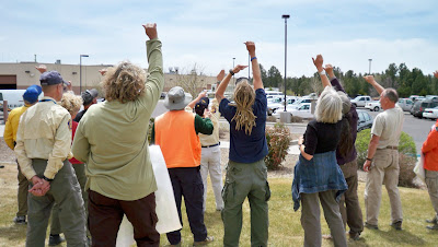 Above, you see students measuring one hand's width, starting from the sun's current location at the outer pinky edge of the hand to find due (true) south at the end of a comfortably extended thumb. It was around 11:30 a.m. at the time, and here in Flagstaff the sun is roughly at due south at 12:30 (though the actual range is between 12:15 and 12:40pm, depending on the time of year). So, being about one hour before "due south time" and each hand width being 15 degrees, or one hour of time in the sky, they measured one hand to the west. If it had been an hour past due south time or 1:30pm, they would have measured one hand width the other way, to the east.
 Once the students each determined true south, they were able to then orient their map (being sure to turn it so the bottom of the map was facing south, rather than turning the top—map north—toward the south by mistake.
Once oriented, they could then determine a direction of travel by placing a pen on the map, one end on their current location and other other pointing toward their destination. (In this case, the latter was a random location for demonstration purposes.) Facing the body in direction of the pen, they would then be able to walk while keeping the sun in the same location relative to their body, at least for a time (because the sun moves... or the earth does relative to it, that is).
Without gadgetry, one could use various other methods of alternative navigation in conjunction with the map to travel to a particular point, comparing actual terrain to the features on the map, using terrain handrails, catch features, check points, and so forth. The key would be knowing your current location and finding it on the map to begin with.
 A little later in the class, Art discussed and then demonstrated how one can determine distance traveled, both by time and by pacing. In this photo above, students are counting paces over a distance of 100 feet, then repeating the process twice more and averaging their results. A single pace is either left-right-left=1 pace or right-left-right=1. In general, an adult takes 18 to 20 paces per 100 feet, or 1,000 paces per mile over "average" terrain. Go downhill and pace will lengthen. Uphill and pace will shorten. Of course, as Art explained, there are errors to these things, but those errors can be reigned in by using other techniques and information on the map.
One case where it would be helpful to have some kind of distance estimate would be when traveling across relatively flat, featureless terrain in the dark and the falling snow. In a scenario like that, it would be a good idea to have an idea of how far you've traveled in the event that the GPS you have malfunctioned. Some people prefer to use time to judge distance, but then you do have to account for any stops and know your average speed.
To keep track of distance by pacing, you can always keep ranger beads on a string or compass lanyard, moving one bead per 100 feet, or you can pick up a pebble or something similar every 100 feet.
So, that's a little of what went on in today's class, along with discussion about map reading, celestial navigation, and techniques for using terrain to one's advantage. This evening, the class will go out to the field to practice, taking turns using alt. nav. skills to move from point to point, partly in the daylight and then extending past dark.
Also, on other "in the news" notes, here are some links to articles about folks who are still missing and some who've finally been found:
Backpacking Light Editor Missing After A.T. Hike — An ongoing search in Virginia along the Appalachian Trail
Body of missing hiker found near Goblin Valley — About a woman who disappeared in the Canyonlands area of southern Utah five months ago
Canyon crews search for 3 missing in Colorado River — In Grand Canyon National Park (This just happened yesterday, and there's still no further news that I've found.)
And this is a REAL old one: A Mystery of the West is Solved — Remains of Everett Ruess found!
(There's more "in the news" news at the end of this post, if you don't feel like reading my ramblings.)
Anyhow, this is day one of the three-day navigation "boot camp" our team is sponsoring, with members of other agencies along with some of our own teammates in the class. I was asked to be an assistant instructor, particularly during the field sessions or if someone needs one-on-one help during any of the classroom exercises.
Today's topic is alternative navigation (navigating without a compass or GPS), and tomorrow is map and compass. Sunday's class will be GPS.
Here are a few photos from today's class, and I'll explain what they're doing:
Instructor Art from our team jumped ahead with the curriculum at the beginning of the class, to get right to determining direction from the sun. He did this because the sun was fading fast as the day clouded up.
 Above, you see students measuring one hand's width, starting from the sun's current location at the outer pinky edge of the hand to find due (true) south at the end of a comfortably extended thumb. It was around 11:30 a.m. at the time, and here in Flagstaff the sun is roughly at due south at 12:30 (though the actual range is between 12:15 and 12:40pm, depending on the time of year). So, being about one hour before "due south time" and each hand width being 15 degrees, or one hour of time in the sky, they measured one hand to the west. If it had been an hour past due south time or 1:30pm, they would have measured one hand width the other way, to the east.
  Once the students each determined true south, they were able to then orient their map (being sure to turn it so the bottom of the map was facing south, rather than turning the top—map north—toward the south by mistake.
 Once oriented, they could then determine a direction of travel by placing a pen on the map, one end on their current location and other other pointing toward their destination. (In this case, the latter was a random location for demonstration purposes.) Facing the body in direction of the pen, they would then be able to walk while keeping the sun in the same location relative to their body, at least for a time (because the sun moves... or the earth does relative to it, that is).
Without gadgetry, one could use various other methods of alternative navigation in conjunction with the map to travel to a particular point, comparing actual terrain to the features on the map, using terrain handrails, catch features, check points, and so forth. The key would be knowing your current location and finding it on the map to begin with.
 A little later in the class, Art discussed and then demonstrated how one can determine distance traveled, both by time and by pacing. In this photo above, students are counting paces over a distance of 100 feet, then repeating the process twice more and averaging their results. A single pace is either left-right-left=1 pace or right-left-right=1. In general, an adult takes 18 to 20 paces per 100 feet, or 1,000 paces per mile over "average" terrain. Go downhill and pace will lengthen. Uphill and pace will shorten. Of course, as Art explained, there are errors to these things, but those errors can be reigned in by using other techniques and information on the map.
 One case where it would be helpful to have some kind of distance estimate would be when traveling across relatively flat, featureless terrain in the dark and the falling snow. In a scenario like that, it would be a good idea to have an idea of how far you've traveled in the event that the GPS you have malfunctioned. Some people prefer to use time to judge distance, but then you do have to account for any stops and know your average speed.
To keep track of distance by pacing, you can always keep ranger beads on a string or compass lanyard, moving one bead per 100 feet, or you can pick up a pebble or something similar every 100 feet.
So, that's a little of what went on in today's class, along with discussion about map reading, celestial navigation, and techniques for using terrain to one's advantage. This evening, the class will go out to the field to practice, taking turns using alt. nav. skills to move from point to point, partly in the daylight and then extending past dark.
Also, on other "in the news" notes, here are some links to articles about folks who are still missing and some who've finally been found:
Backpacking Light Editor Missing After A.T. Hike — An ongoing search in Virginia along the Appalachian Trail
Body of missing hiker found near Goblin Valley — About a woman who disappeared in the Canyonlands area of southern Utah five months ago
Canyon crews search for 3 missing in Colorado River — In Grand Canyon National Park (This just happened yesterday, and there's still no further news that I've found.)
And this is a REAL old one: A Mystery of the West is Solved — Remains of Everett Ruess found!
Guess What I Got (And Training & News Too)
Heh heh, a new toy! Yep, now I can be a pest and take pictures—video too—of all things SAR. (Added later: This was a bit before cell phones had good cameras or maybe any cameras.) I'm photographically challenged, but I'll do my best to add some pizazz to my babbles from here on out with some images, though I'm sure, at times, it won't be possible—or right—to take pictures while on missions. Here, look, I think I figured out how to point and shoot:

That's the team, getting ready for some training earlier today, on line search and probability of detection. We had a good turnout—15 of us, I believe, including four from mounted with their horses.

Here's how it worked:
Yesterday, our team captain and other volunteers set up the course. They put out a bunch of five-gallon buckets, all painted brown to blend in with the surroundings. These buckets were spread out among the ponderosa pine, which is fairly open terrain but still littered with forest debris, rocks, and stumps, the latter resembling the buckets (or, rather, vice versa).
Behold Nelson and a bucket...

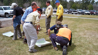
Today, we split into teams of three or four and, team by team, determined our critical spacing. That means an object roughly the same size as what we'd be looking for (in this case, it was an identical brown bucket) was set on the ground, and each person walked away from it to the point where they could still see the bucket and identify it as a bucket. We then counted our paces from that point back to the bucket. The average of each team's results was the critical spacing used for that team's line.
Now, using critical spacing usually means each person is twice that measured distance from the next searcher. That way, if the object is exactly between two people, it could still be seen. Critical spacing is affected not only by the size of the object—which, of course, could be as big as an unresponsive person or as small as a bullet—the terrain, the amount of brush, the weather, and so forth. Given the conditions and size of the objects today, our team's critical spacing turned out to be 30 paces, or roughly 90 to 100 feet, which meant searchers could be 60 paces, or about 200 feet, apart.
Given the size of the search area, however, and the number of people in our lines, we spread out at half critical spacing, or 30 paces apart (except for the mounted folks, who went two at a time, 60 paces apart). We all had radios in order to communicate rather than shouting down the line. We'd say, "Team 1, stop" or "Team 1, start," stating our team number first because there were other teams in the field, to start and stop our lines moving forward at intervals.
This photo shows the distance between me and my next teammate in the line, while another teammate paces off to his spot further out.

So, okay, each time a team member spotted a bucket, they would stop the line without pointing to the sighted bucket and write down the GPS coordinates of their current location, the direction of the bucket from their location using positions on a clock, and then their approximate distance from that bucket.
Sometimes, when the line stopped, other team members would spot the same bucket. Other times, the line would start up again, only to be stopped one step later when someone else spotted that or a different bucket. So it was stop and go, stop and go. We didn't know until we finished how many buckets were in the field.
I know, this sounds awfully thrilling, doesn't it? But I enjoy searching, not to mention the company of my teammates, and this was like a treasure hunt to me. It was also good practice for staying in our grid, keeping an eye on the person to our right and maintaining our spacing. That's much more challenging in more variable terrain and denser brush than we had today, though.
After the exercise, we all gave our notes to our coordinator, who's going to do some calculations and explain the results at our next meeting. Until then, I'm not really sure what kind of POD information he'll give us, but I'll let you know when he does.
So that was today's event. That and playing with my new camera and getting some news. Members of our team, along with the adjoining Yavapai County SAR team and others, have been searching on and off for more than two and a half years for a plane that disappeared in the Sedona area. That plane, flown by William Westover, a private pilot from Phoenix, with his passenger Marcy Randolph, has been found in a canyon in the Secret Mountain Wilderness. Here's the article from the Arizona Daily Sun: Plane wreckage identified.
Oops! There goes my pager! Gotta run...

That's the team, getting ready for some training earlier today, on line search and probability of detection. We had a good turnout—15 of us, I believe, including four from mounted with their horses.

Here's how it worked:
Yesterday, our team captain and other volunteers set up the course. They put out a bunch of five-gallon buckets, all painted brown to blend in with the surroundings. These buckets were spread out among the ponderosa pine, which is fairly open terrain but still littered with forest debris, rocks, and stumps, the latter resembling the buckets (or, rather, vice versa).
Behold Nelson and a bucket...

Today, we split into teams of three or four and, team by team, determined our critical spacing. That means an object roughly the same size as what we'd be looking for (in this case, it was an identical brown bucket) was set on the ground, and each person walked away from it to the point where they could still see the bucket and identify it as a bucket. We then counted our paces from that point back to the bucket. The average of each team's results was the critical spacing used for that team's line.
Now, using critical spacing usually means each person is twice that measured distance from the next searcher. That way, if the object is exactly between two people, it could still be seen. Critical spacing is affected not only by the size of the object—which, of course, could be as big as an unresponsive person or as small as a bullet—the terrain, the amount of brush, the weather, and so forth. Given the conditions and size of the objects today, our team's critical spacing turned out to be 30 paces, or roughly 90 to 100 feet, which meant searchers could be 60 paces, or about 200 feet, apart.
Given the size of the search area, however, and the number of people in our lines, we spread out at half critical spacing, or 30 paces apart (except for the mounted folks, who went two at a time, 60 paces apart). We all had radios in order to communicate rather than shouting down the line. We'd say, "Team 1, stop" or "Team 1, start," stating our team number first because there were other teams in the field, to start and stop our lines moving forward at intervals.
This photo shows the distance between me and my next teammate in the line, while another teammate paces off to his spot further out.

So, okay, each time a team member spotted a bucket, they would stop the line without pointing to the sighted bucket and write down the GPS coordinates of their current location, the direction of the bucket from their location using positions on a clock, and then their approximate distance from that bucket.
Sometimes, when the line stopped, other team members would spot the same bucket. Other times, the line would start up again, only to be stopped one step later when someone else spotted that or a different bucket. So it was stop and go, stop and go. We didn't know until we finished how many buckets were in the field.
I know, this sounds awfully thrilling, doesn't it? But I enjoy searching, not to mention the company of my teammates, and this was like a treasure hunt to me. It was also good practice for staying in our grid, keeping an eye on the person to our right and maintaining our spacing. That's much more challenging in more variable terrain and denser brush than we had today, though.
After the exercise, we all gave our notes to our coordinator, who's going to do some calculations and explain the results at our next meeting. Until then, I'm not really sure what kind of POD information he'll give us, but I'll let you know when he does.
So that was today's event. That and playing with my new camera and getting some news. Members of our team, along with the adjoining Yavapai County SAR team and others, have been searching on and off for more than two and a half years for a plane that disappeared in the Sedona area. That plane, flown by William Westover, a private pilot from Phoenix, with his passenger Marcy Randolph, has been found in a canyon in the Secret Mountain Wilderness. Here's the article from the Arizona Daily Sun: Plane wreckage identified.
Oops! There goes my pager! Gotta run...
Those Wonderful Search & Rescue Dogs

We do have a couple of search dogs on our own team—Cassie, our ground-tracking German shepherd, and Scout, an air-scenting brown Lab—but it's always a treat to meet others and see how they work.
Since Cassie joined our team about a year and a half ago, I've read some about SAR dogs, and I'm really interested in what they can do and how they're trained, though I doubt if I'd ever make that big commitment to become a handler. For one, I currently have a much-loved pup of 11 years, who'd not take kindly to sharing my attention. And once Sassy is no longer with us, I think it'll be a while before my husband and I own another dog (update: that turned out not to be true). Not with my plans for future multi-month thru-hikes and our intention to travel as extensively as possible. Someday, I'm sure we'll have another dog, but whether I'd want or be able to put in the time necessary to properly train a search and rescue canine would remain to be seen.
Anyhow, during our fieldwork this weekend, I enjoyed watching how each dog alerted differently during exercises. Some would bark, one would do circles (wing-dings, I call them), and another, a Weimaraner, basically body-checked her handler. They'd get so excited when it was time to work, which was usually communicated by their handlers putting certain collars, often with bells, or working-dog vests on them.
Also fascinating to me are the various commands and signals that pass between handlers and their dogs. For instance, one handler, Terry, explained to me that there's a difference between the command they give for a live person search and a search for a cadaver, and the dogs actually understand that difference. She explained that the dogs are "proofed" for certain animal bones so they ignore those of deer, elk, and other animals that aren't human. Terry and the others were gracious in answering the many questions my teammates and I pestered them with throughout the day.
Besides the treat of watching the dogs, it was also great to meet members of another SAR team as we sometimes do during big, multi-agency missions and at conferences. I enjoy learning about how they do things—sometimes quite differently than our own team—and what kinds of searches and rescues they've been on lately. I never get tired of the stories.
That's one reason I've put together the Search & Rescue Stories website, where I collect firsthand accounts by rescuers and the rescued and keep directories of websites for SAR teams around the world. I also participate on the SAR-L Discussion List, with topics ranging from techniques, training, and management to SAR tips, gear, news stories, and more. You can find a list of additional search and rescue online forums on my website in the "Articles & More" section.
Anyhow, other than some trainings lately, a litter-carry call that I hear was mostly handled by emergency medical personnel who were notified and quickly responded to the scene, and one 10-22'd call-out for a lost hiker who showed up just as we were loading gear at the SAR building, it's been relatively quiet for the past few weeks. Next weekend is the POD (probability of detection) and line search training, and then the three-day navigation "boot camp" begins on May 1st. The warming weather makes these activities much more enjoyable.
Three Ongoing Searches
This is one of them, as reported on the Arizona Daily Sun website this afternoon:
We'd discovered some tracks thought to belong to the boy and were following them when our crew of bleary-eyed searchers were relieved by fresh eyes this morning.
Also in today's edition of the Arizona Daily Sun was this news about the continued search for Mark Irby, which began on January 2nd of this year:
Meanwhile, we've yet to find the man from the van abandoned along Interstate 17 near the scenic vista south of Munds Park.
Nine contiguous days of search and rescue activity for our team... and counting. And not so long ago, I'd remarked about how quiet it had been for more than a month.
Now off to the shower and to squeeze in some errands before an early bedtime. I have a feeling our pagers will be going off today for more searching tomorrow.
Update at 12:50 p.m.:
I just found out via Twitter that the boy has been found! Sounds like he's okay. At 12:47 @FlagstaffNews posted: "Searchers found 7-year-old boy who spent night in forest after getting separated from group yesterday. He's being checked out now."
And a few minutes later, this breaking news story showed up on the Arizona Daily Sun website: Searchers Find Missing 7-Year Old Boy. Phew!
7-year-old boy missing near Red Mountain
"A 7-year-old boy who was on an outing near Red Mountain with a group from The Guidance Center in Flagstaff has been reported missing.
"According to information from the Coconino County Sheriff’s Office, Michael Sandoval has been missing since about 3 p.m. Monday in the Red Mountain area off Highway 180 about 30 miles north of the city. He was part of a group of three adults and 10 clients from TGC. He was last seen wearing a black ball cap with an image of a white bear in the front, a medium to dark blue shirt with the word 'baseball' on the front in white letters. He also was wearing blue jeans and skateboard shoes.
"Search and Rescue crews on the ground and an Arizona Department of Public Safety helicopter crew have been searching the area.
"Anybody traveling on Highway 180 in the area of Red Mountain are asked to watch for the missing child and to contact sheriff’s officials if the boy is sighted by calling 774-4523 or 1-800-338-7888."
We'd discovered some tracks thought to belong to the boy and were following them when our crew of bleary-eyed searchers were relieved by fresh eyes this morning.
Also in today's edition of the Arizona Daily Sun was this news about the continued search for Mark Irby, which began on January 2nd of this year:
ATV belonging to missing man found
"The recent discovery of the ATV belonging to a Valley man who went missing from his Forest Lakes vacation home earlier this year has reignited the search for the man.
"According to information from the Coconino County Sheriff's Office, on Saturday, two men on a hunting and fishing trip found the red Bombardier ATV belonging to Mark R. Irby abandoned off Forest Service Road 170, about a mile southeast of Chevelon Canyon Lake and about 12 miles by road from Irby's cabin. Irby, 51, was last seen riding the ATV on Jan. 2. According to family members, Irby was going to take a short ride around the subdivision before returning to his primary home in Chandler. He was not dressed to hike or spend an extended amount of time in the woods, which had a deep snow pack at the time.
"On Sunday, police and search and rescue volunteers began combing the area where the ATV was found and intensive search efforts will continue throughout the week. Searchers had not previously covered the Chevelon Canyon Lake area.
More than 1,800 hours have been invested in the search for Irby."
Meanwhile, we've yet to find the man from the van abandoned along Interstate 17 near the scenic vista south of Munds Park.
Nine contiguous days of search and rescue activity for our team... and counting. And not so long ago, I'd remarked about how quiet it had been for more than a month.
Now off to the shower and to squeeze in some errands before an early bedtime. I have a feeling our pagers will be going off today for more searching tomorrow.
Update at 12:50 p.m.:
I just found out via Twitter that the boy has been found! Sounds like he's okay. At 12:47 @FlagstaffNews posted: "Searchers found 7-year-old boy who spent night in forest after getting separated from group yesterday. He's being checked out now."
And a few minutes later, this breaking news story showed up on the Arizona Daily Sun website: Searchers Find Missing 7-Year Old Boy. Phew!
Same Subject, Different Day
Déjà vu set in—see Once Was Not Enough from 3/31—as I listened to our coordinator's message even before my pager had finished playing its song. (I'm a fast hand when it comes to grabbing the phone to call in for a SAR mission. Like lightnin'.) Sergeant D said this would be a search for the same man who'd been rescued the night before.
Night before? I checked my pager. Nope, no old pages that I'd missed. Must have been a direct call to certain team members, I figured. Which turned out to be the case. They needed volunteers certified to drive the snowcat and snowmobiles, and, though I'm able to operate both, at least to some extent, I haven't been properly trained or certified by the team. Hopefully, I'll have the opportunity to get that done in the near future.
Anyhow, this man had gotten his vehicle stuck on a Forest Service road on Christmas Day. And what a day that was, with heavy snow and wind gusts texceeding 40 miles per hour. As much as I get all revved up when there's a SAR call, I do admit I wasn't thrilled at the idea of going out in that weather. (But I woulda.)
So, from what I understand, people in three other vehicles had attempted to help the stranded motorist, and they too became stuck. According to the article in the Arizona Daily Sun, search and rescue crews spent much of Christmas rescuing a large group, including children and dogs. Then on Friday, one of the former rescue-ees attempted to hike back to his vehicle and hadn't been seen for two hours. I gather from the article that the subject must have had a cellphone and informed members of his party he could no longer continue hiking. So a call for a second round of help was made.
When I arrived at The 105 building after a slow drive across town, concerned about icy roads, a few of my teammates were already there, readying the snowcat for another run and hooking up the trailers loaded with snowmobiles. As I tossed my personal gear into one of the vehicles, the house phone rang. It was our coordinator, asking if everyone had snowshoes. All shouted affirmatives.
Have I mentioned yet how much I love my new snowshoes? I bought them just after returning from the last mission in Forest Lakes and have been using them every day since. Not only is it great exercise—I've heard you can burn 600 calories per hour on those things—but I really enjoy being out amongst the ponderosa pines on virgin snow, untouched except for all the critter prints crisscrossing my path. I walk out my door, 'shoe into the forest, and immediately see that elk, mule deer, jackrabbits, Abert squirrels, a fox, and even a bobcat have recently been out and about. As far as I'm concerned, all this snow can stick around until at least March. I looove my snowshoes.
Anyhow, where was I? Oh, the mission...
As it turns out, it was a pretty dynamic situation, and plans changed rapidly. No longer were snowshoers needed, just the snowcat and snowmobile drivers again. So off went several of my certified teammates, and the rest of us reorganized the SAR building to make room for the trailers when the others eventually returned, and then we headed home.
As I learned from the morning paper, the cold and disoriented man was picked up by an Arizona Department of Public Safety helicopter at 8 p.m. and flown to Flagstaff Medical Center.
Well, it's past my bedtime—unless my pager goes off again, that is—but maybe I'll just take the trash out on my beloved snowshoes before I hit the sack.
Checking the SAR Line
I thought I'd do a test to see if the trend will continue. Ready? Drum roll, please...
Gee, it's been REALLY QUIET LATELY!
Ten... nine... eight...
I called the SAR phone number today, to be sure the most recent message about a call-out was the last one I heard when my pager went off at 2:30 a.m. on November 24. That mission was 10-22'd (cancelled) pretty quickly as I was en route to The 105 building. So I called to be sure my pager was working. Yep, I haven't missed anything. Still the same message from the 24th, about a lady missing near Williams.
Seven... six... five...
Before that was the plane crash in Sedona. So it's been over two weeks since we've had a call-out. Wow, I'm getting used to sleeping through the night.
Four...
Read some good search and rescue books lately, during all these quiet evenings at home (with my pager next to me on the nightstand, of course). The first was Lost In the Yellowstone: Truman Everts's Thirty Seven Days of Peril written by Truman Everts himself, who was—you guessed it—lost in Yellowstone (before it was a National Park). That was back in the late 1800s and apparently is still the longest anyone has gone missing in that area and been found alive... though not far from death in Evert's case. A thin book and a good read but a little challenging with all of the side notes, some of which are about the concurrent movements by the rest of Evert's party and others who went looking for him.
Three...
Then I read Coming Home from Devil Mountain by Eleanor Dart O'Bryon, who became separated from her fiance while climbing Picacho del Diablo in Baja, Mexico, and both were stranded without food for nearly three weeks. Another quick read, composed mostly of interlocking journals kept by Eleanor while alone on the mountain, starving, and her father, who mounted a search effort with the Sierra Madre SAR team.
TWO...
And my definite favorite of the three is Coming Back Alive: The True Story of the Most Harrowing Search and Rescue Mission Ever Attempted on Alaska's High Seas by Spike Walker. For me, it was one of those "I don't care how tired I'll be at work tomorrow, I've gotta keep reading" books. Totally distant from any experience I'll ever have, I found it fascinating.
One and a HALF...
So, no Coconino County SAR news (that I know of) to report for now. There's probably been plenty going on that just hasn't required volunteers or at least nothing that necessitated paging the whole team. Sometimes, certain team members with a lot of experience or specific skills are called directly to help with specialized missions. We usually hear about that stuff at our monthly general meetings.
One and a QUARTER...
But I'll be back as soon as I have something SAR to share.
ONE!
Hm.
Gee, it's been REALLY QUIET LATELY!
Ten... nine... eight...
I called the SAR phone number today, to be sure the most recent message about a call-out was the last one I heard when my pager went off at 2:30 a.m. on November 24. That mission was 10-22'd (cancelled) pretty quickly as I was en route to The 105 building. So I called to be sure my pager was working. Yep, I haven't missed anything. Still the same message from the 24th, about a lady missing near Williams.
Seven... six... five...
Before that was the plane crash in Sedona. So it's been over two weeks since we've had a call-out. Wow, I'm getting used to sleeping through the night.
Four...
Read some good search and rescue books lately, during all these quiet evenings at home (with my pager next to me on the nightstand, of course). The first was Lost In the Yellowstone: Truman Everts's Thirty Seven Days of Peril
Three...
Then I read Coming Home from Devil Mountain
TWO...
And my definite favorite of the three is Coming Back Alive: The True Story of the Most Harrowing Search and Rescue Mission Ever Attempted on Alaska's High Seas
One and a HALF...
So, no Coconino County SAR news (that I know of) to report for now. There's probably been plenty going on that just hasn't required volunteers or at least nothing that necessitated paging the whole team. Sometimes, certain team members with a lot of experience or specific skills are called directly to help with specialized missions. We usually hear about that stuff at our monthly general meetings.
One and a QUARTER...
But I'll be back as soon as I have something SAR to share.
ONE!
Hm.
Recent SAR Happenings
No call-outs since the Sedona plane crash, but some other news and events to share...
We had an Alternative Navigation class on Saturday, November 15. By "alternative navigation," I'm referring to navigation without the use of gadgets such as a compass, GPS, or altimeter. Skills we learned and practiced in the field included navigating by the sun, celestial navigation, and using terrain to our advantage with techniques like aiming off, safety baselines, funneling, catch features, pacing, and more. Let me just say, this stuff takes practice!
I took this course, taught by one of our team's navigation experts, last year and intend to take it every time it's offered. These are skills that definitely require time and repetition to master and continued use to keep sharp. I find celestial navigation fascinating, and I was so impressed by our instructor's knowledge. And a little jealous, too.
Anyhow, I wrote an article about Alternative Navigation on my SARstories blog. Click here if you're interested in taking a look.
A writer from the Arizona Daily Sun took the classroom portion of the Alt. Nav. training and, that afternoon, a photographer accompanied us for a short time in the field, so a newspaper article is in the works. I'll let you know when it appears.
In other news, several specially selected team members went out to the Little Colorado River in the area of Hopi Salt Canyon to collect some evidence located by the U.S. Fish & Wildlife Service. The evidence was potentially connected to the case of Reinhard Kirchner, a German national who went missing in early spring 2007. In April of last year, after 61 year-old Kirchner failed to meet his fiancee in Las Vegas as planned, his abandoned vehicle was found near the north rim of the Little Colorado River gorge. A large ground and air search involving multiple agencies and counties followed, but after six days of searching about 56 square miles of rugged terrain, the SAR mission was called off.
At our general meeting last night, Sergeant D said the items Fish & Game found could just be a river runner's stash. Still, investigation continues, including the potential for DNA testing on the items.
Also at last night's meeting, we were told that the pilot from the downed Piper near Sedona, 51-year-old Rockney Mark Herring, is still alive and has been stabilized. Apparently, he's also been awake. Boy, is that great news!
And with that, I'm off to the uniform shop to pick up my new, very yellow winter coat (it's one of our team colors, you see) that now has search and rescue patches on it. That way, people will know why I'm wearing a bright yellow winter coat and won't just assume I'm either color blind or unfashionable.
PLBs and Plenty of Zs
I'm still here! Didn't want you to think I'd gotten tired of SAR blogging. No, there just hasn't been a lot of action lately. At least, nothing that's panned out.
We did have a call last Monday morning, I think it was, around 9 a.m. I was in Walmart at the time (yippee!), looking for stuff for our new house, when my back pocket started beeping a tune. A 200 (search) page for a couple of overdue woodcutters on or near the Hualapai Reservation, which is about a three-hour drive from Flagstaff.
It turned out to be a good drill, basically. Several of us proceeded to load tech gear, ATVs, the Ranger UTV, cubes of water, MREs and snacks, and full gas cans, then drove for about 15 minutes before the mission was 10-22'd. The woodcutters had been located near Peach Springs. So we did an about-face, returned to the SAR building, and unloaded and put away all the gear. And that's been about it over the past couple of weeks. I've had way too many full nights of sleep. I'm thinkin' something will happen soon.
Oh, and we did have another cancelled call-out on the afternoon of Saturday, October 25, just as we were finishing up a rather frustrating personal locator beacon, or PLB, training. (I'll get back to that in a sec.) It sounded like a pretty dire call at that. A girl—not sure if it was an adult or child—had been attacked by bees about four miles up the West Fork of Oak Creek, and she was having an anaphylactic reaction. It was going to be a tough litter-carry, possibly involving some wading in places where the creek fills the canyon. And word through the grapevine was that first responders (not sure if that meant medics, deputies, or civilians) were already "working a code." So we were thinking this might end up being one very rugged body recovery by the sound of things.
On my way across town to the SAR building, though, the mission was cancelled. At the time, I thought perhaps the girl had been short-hauled since her condition was apparently very serious. But I later found out she'd been given epinephrine and walked out on her own. Glad to hear that.
So, back to the PLB training. To read specifics about this and other types of devices used to transmit distress signals, you can visit the Search and Rescue Satellite-Aided Tracking, or SARSAT, website. As for me, I refer to the thing that emits the distress signal as a "gadget," and the device responders use to track down the gadget (and hopefully the person/s needing help) as a "gizmo." Gadget and gizmo... got it?
So, first we had a classroom session. We learned about the different types of beacons—PLBs used for land-based applications, ELTs for aviation use, and EPIRBS for maritime use—and the basics of how they work. Seemed pretty straightforward at that point.
Then, we went out behind the Sheriff's office, where Sergeant D turned on the training PLB gadget, and we walked a couple hundred yards across the parking lot where we used the gizmo to locate the gadget. Of course, we could see the gadget from where we were standing with the gizmo. Straight line, no obstacles, flat terrain. I understood how it worked and figured, hey, this is easy!
And then it was time to take the gadget and gizmo into the field. We relocated to Fort Tuthill, where the plan was to take turns going off into the woods with the gadget with about a 10-minute head start, and then the rest of the group would use the gizmo to locate the source of the distress signal.
Well, the first time out, things went fine. Trees, yeah, but pretty flat. Now, the gizmo, by the way, makes a continuous, rather annoying sound—a constant, high-pitched, whiny beep—which the responders have to listen to the whole time they're searching. This first trial didn't take us that long so none of us mentioned anything about stomping on the whiny thing. Second time around, though: different story.
We were all over the place, with me using the gizmo for the first hour. At least, it seemed that long. But the thing couldn't seem to make up its gizmo mind. I was getting conflicting signals, first this way and now that. We were now in hilly terrain with lots of rocks and other obstacles, and I guess the signal was bouncing all over the place.
Eventually, I held the gizmo out to Sergeant D and asked (trying not to sound desperate), "Do you wanna try?" thinking at that point, I must be doing something wrong. I'm not sure what our leader was thinking, but he wasn't saying much as the rest of us followed him follow the gizmo.
A few members of our team, who'd been using the low-tech method of detecting a PLB signal with a radio set to a certain frequency and a body shield (if you really want an explanation, feel free to let me know in the blog comments, and I'll give it my best try), had disappeared. I hadn't noticed they'd walked off, leaving just me and another lady following Sergeant D. I looked around and didn't see them anywhere.
Eventually, Sergeant D radioed the others, and we learned they'd found the guy with the gadget a long time ago. What? The gizmo had failed us while the low-tech method had worked? When I saw where the guy with the gadget had been the whole time, I realized we'd passed pretty close to his location early on in the search. Ugh.
So, then Sergeant D took the low-tech method out of the equation, grabbed the gadget, wished the rest of us luck, and took off to hide. Basically, the gizmo took us in a huge circle, leading us to think Sergeant D was on the move with the thing the whole time. So, a moving distress signal, right? We even thought, based on the signals we were getting, that he'd gone back to the vehicles. But, when we got there, not only was there no sign of Sergeant D, but the gizmo was registering no signal at all. Nada. Dead.
Frustrated, we called Sergeant D on the radio, and he gave us coordinates. We used our GPSes to go to those coordinates, thinking we were looking for him and/or the gadget, but we soon realized he'd gotten us fairly close but not right to the spot. He continued to give us hints; we continued to try to follow the directions the gizmo seemed to be leading us in, but we wandered all over the place with no luck. Finally, thankfully, Sergeant D called the whole thing off. We'd apparently walked right by him more than once.
Was it the hills and obstacles interfering, making the signal bounce all over the place? Or was it us, the searchers using the gizmo, who were the problem? What I do know is that I was hearing that whiny beep in my dreams for several nights thereafter.
A Life Saved After All
I don't think any of us knew just how serious his condition really was. I'm referring to the man we recently evacuated from the Humphreys Trail after he'd experienced shortness of breath and chest tightness during his descent. While members of our SAR team along with Guardian crew were bringing him down in the litter, medics monitored the patient's condition. It seemed the longer he was on oxygen and the lower we went, the more his condition improved. He was talkative and not in any further distress, he said.
According to Sergeant D, though, who updated us at our general SAR meeting this past Thursday, the patient had a blood clot in his stint. Had he attempted to walk, he may have had a serious, potentially fatal heart attack.
When our coordinator gave us this news, Liz and I looked at each other with wide eyes. Sometimes you don't know what a difference a rescue is making in someone's life during the mission. Boy, I'm glad the Good Samaritan called for help when he came across Andrew sitting by the side of the trail.
On another note, we were paged at 1:15 Friday morning for a missing hunter with a history of diabetic coma. The man's companion had last seen him at 4:00 p.m. on Thursday, before he'd left in his truck from their camp in a remote area near the South Rim of Grand Canyon. The man had mentioned that if he did leave, he'd be going to a particular tank (a watering hole for livestock). But his friend had checked that tank and then drove around for another five hours without any luck. Then he called for SAR.
Coconino County is so big that it can take us a long time to get to an area before we can even begin to search. In this case, the point last seen was 30-some-odd miles down a dirt road and a nearly three-hour drive from Flagstaff. Two deputies were already in the area while we were on our way, gathering additional information and driving the network of dirt roads and two-tracks. At first light, we'd have the assistance of the DPS helicopter, too.
But as we were nearing the hunters' camp, we heard one of the deputies on scene call Sergeant D. "I hate to do this to you," he said. Al turned up the radio, and we leaned in to listen. Sure enough, they'd just made cellphone contact with the subject, who was about a mile and a half from camp, Code 4. He was fine, he said. No diabetic issues.
Al and I couldn't help but laugh—this kind of timing has happened a number of times before. But good, that's the end result we always hope for. After a little shut-eye for an hour, we turned around and drove back to Flagstaff.
Some PSAR: The Highpointers Are in Town
Mission-wise, things have been quiet for the last couple of weeks, since Labor Day weekend. But our SAR team has had some PSAR to do in the meantime. PSAR stands for preventative search and rescue, which basically involves walking heavily used trails and stationing ourselves in high-visibility areas to answer questions, make sure folks are prepared for what they're doing or setting out to do, and sometimes disseminating informational brochures or just saying a friendly hello to passers by.
This week, the Highpointers are in town for their "konvention" on Humphrey's Peak. Until one of our SAR general meetings a couple of months ago, I hadn't heard of this club with a membership that has an age range of something like five years to 90. The club's purpose, as quoted from their website, is to "promote climbing to the highest point in each of the fifty (50) states; provide a forum for education about the highpoints; aid in the preservation and conservation of the highpoints and their environs; provide a vehicle through which persons with this common goal can meet and correspond with one another; maintain positive relationships with owners of highpoints on private property; assist in the care and maintenance of highpoints; and support public and private efforts to maintain the integrity of and access to state highpoints." Got all that? I've even heard that some club members try to hit high points in all counties as well.
Anyhow, with something like 350 more people than usual hiking Humphreys and other popular Flagstaff trails this week, our SAR team did some planning, parked a command trailer up at the Snowbowl ski area at the Humphreys trailhead, and made ourselves noticeable and available on the mountain, hiking (and riding horses) around with our SAR shirts and radios on. Our goal was not only to do some PSAR but to have team members in the area in case an incident were to occur. It's now Friday morning, the final full day of the Highpointers event and, so far, all is well.
I think the Highpointers Club is pretty cool. And being a list-maker and a goal-oriented girl myself, this makes me go, "Hmm..."
 And thank you, Renee from Tidewater Search & Rescue for telling me about a book written by a Highpointer. She tells me it's a fun and easy read, by two men who completed the 50-state quest. It's called, To The Top: Reaching for America's 50 State Summits.
Subscribe to:
Posts (Atom)