On Sunday evening, my pager went off at about 6:15. I signed in at the SAR building at 6:45. At maybe 7:30, four of us were on the road. At, oh, 10 p.m.-ish, we pulled over en route to the far reaches of our county near the Arizona/Utah border. The overdue hikers had been located.
Standing around at the side of the road, we listened to radio traffic, and our coordinator made some calls. At 10:30 give or take, after star-gazing for a bit and checking out the night vision goggles, we headed back to Flagstaff. The subjects had been spotted by the helicopter crew and scooped up, dehydrated but otherwise okay.
At 1:00 a.m. Monday morning, we were back at the SAR building. After refueling the vehicles and unloading the ATVs, UTV, and all the rest of the equipment, we headed home.
Tah-dah! Maybe my shortest blog post yet!
Yes, but wait till later, after I've gotten a little sleep. We were out all night again last night.

These are my stories as a volunteer member of the Sheriff's Search and Rescue team in Coconino County, Arizona. I'll share what it's like to go from a beginner with a lot to learn to an experienced and, hopefully, valuable member of the team, as well as the missions, training, and other activities along the way.
Rock Rescue Academy Continues
I think I've aged about 50 years overnight. Let's just say, I'm getting well-acquainted with muscles I must have been ignoring for far too long as I shuffle around the house this morning, oo-ing and mpf-ing.
For a while yesterday, as I was dangling from a tree limb, spinning and bumping into the trunk, struggling to do what I thought looked pretty straightforward, I was about ready to give up. Matter of fact, when I took a break to rest my quivering muscles and give someone else a chance to practice ascending before moving to actual rock walls, I had to bite my lip hard to keep from crying. I was pissed (at myself.). I really want to be able to do this. I really want to pass that proficiency test in June.
Here's a picture of a teammate going right up the rope. The one manning the belay kept letting out the line so we had more to climb than the actual distance from the ground to the branch:
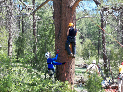
After time spent collecting my thoughts and some personal attention from a teammate who graciously tried to help me get the hang of the movements, I was back to the tree. Again, what seemed to come easily to others—and what I thought should come easily to me too, because I'm not uncoordinated (you should see me Jazzercise!)—I was again at a loss.
UNTIL one of the guys said, "Hey, why don't you try it one-legged." He explained what to do. I took my right foot out of the right "step" (steps in this case are loops made of webbing), followed my teammate's instructions on how to alter the movement, and right up I went! I was so thrilled. In fact, I heard someone on the ground say, "She's going up faster than anybody." I wanted to cry again but this time because I was elated.
And then I went to the bottom of the cliff. I thought, hey, no problem now; I can do this! But the fatigue from the stress and overexertion on the tree had worn me down. My legs were shaking and every arm and back muscle was tight. As soon as I started up, I knew I was in for a long, slow grunt to the top.
On both ascents, I had trouble getting started, which fatigued me even more. When I finally did get moving upward, I used some quiet swearing to help me along, particularly over the difficult sections where there was overhanging or "bulging" rock.
Matter of fact, just below the top edge on my first ascent, I thought I might have to go all the way back to the bottom. I just couldn't seem to make the moves to get past the overhang, and I was having the hardest time getting a foot or leg up to where I could heave myself away from the rock. I needed to get the rope off the rock so I could "throw" the ascender past that bulge in the cliff. The teammate manning the edge was leaning over, trying to talk me through it, saying, "Now, there are a couple of things we can do here. You can put your foot here on this ledge and push yourself up..." Uh-huh. My foot would have been right about the level of my ear. Nothing I tried seemed like it was going to work.
But, finally... somehow... and I couldn't tell you how... I was on top. I'm amazed I didn't fall right over in one big exhausted lump of limbs and gear. My legs and the rest of me was Jell-o.
By the end of the second ascent, though, I was actually starting to find my rhythm and figure out the technique that worked best for me. I managed to get past bulges (I don't know what else to call them) with much less struggle. But I didn't have the energy left for a third go-round to see if I could do it even better. It would have completely done me in, and we still had hours of training ahead of us.
So after a break...

...we moved on to anchor-building...


We covered a lot yesterday, and today I wonder how much I've retained, both mentally and physically. I'm definitely going to take my experienced teammates up on their offers to meet us newbies at the SAR building for some extra practice between trainings. I'll have to if I'm ever going to pass the proficiency test at the end of the five-week acadeby. If I do, it'll be a big accomplishment for me. But if I don't, I'm going to keep trying and working at it until I do!
######
I found this YouTube video, which shows the technique I was using, with one foot in the step, the other loose. Now, why does this look so easy here? One thing, though ... this guy, for the most part, is ascending away from the rock face, with no overhangs:
Searching x 2, Rappeling x 6
So, the last time we met here, I was returning from one search and heading right out for another. Basically, I got back from the search for the missing elderly woman with the chihuahua, grabbed a Gatorade and the keys to the Expedition from my teammate who'd just driven the last leg, and off we went again.
This was a search for a woman who'd apparently been... um... dropped off on a backwoods road. Somewhere. She'd called for help on her cell, but before deputies could locate her, the cell phone had (apparently, again) died, and the cell tower ping was inconclusive as to the bearing and distance of the caller's location. (Apparently once more...) The woman had no idea where she was but said she'd stay put in the middle of the road. Before her cellphone had died, she'd reported hearing a deputy's siren in the distance, so some general idea of her whereabouts was known.
Okay, so enter SAR. We split up in twos, six in vehicles and a pair on the Polaris UTV, and we began driving roads, entering the general area from various locations. And we drove and we drove, clearing road after road.
Fast forward: Two-thirty a.m. and no lost lady, and those of us who'd been searching since 1:00 the day before were sent home. By 1:00 on Friday afternoon, still no lost lady. At approximately 3:30 that same day, however, not-lost lady and her "friend" drove by SAR and a deputy on a dirt road we'd already checked and re-checked.
Conclusion: Maybe-never-really-lost lady had spent the night, warm in a sleeping bag and tent, not on said road. And I suppose 'nuff said, too.
I had just enough time after returning to the SAR building, filling up the vehicle, and putting equipment away to stop for dinner before heading to meeting #1 for the Rock Rescue Academy, this year's training series for technical rescue team wanna-be new recruits. Needless to say, I was yawning and not performing well as we learned knots. My brain had come to a complete halt by 9 p.m.
The next morning, when we reconvened for Day #1 of the rock rescue field course, I somehow tied a darn near perfect fisherman's knot while listening to one of our instructors go over the plan for the day. Maybe there was hope for me yet!
An hour later, I was standing on a cliff, hooked up to a safety line, sloooowly tying a figure 8 with a follow-through, rigging the belay line to my harness, then rigging the Rescue 8 descender under the watchful eye of an experienced teammate. Next came the safety check (good thing because I hadn't locked the carabiner), and then I walked backward off the cliff.
The adrenaline was pumping, but alas, I walked myself down the rock wall and stepped down onto solid ground still in one piece. I untied and unhooked myself, said a happy, "belay off!" and then "rappel off!" and tried to hide my giddy excitement. I did it! Then I did it again. And again. And again.
Okay, so I ended up with a few scratches from the bush I lowered my butt into on one rappel. And then there was the wee slip and clunk I did when first going over a tricky edge. Each time I got one thing right, I screwed up or blanked on something else. But I did have one clean rappel at the end, where I hooked myself up, passed the safety check, and went from top to bottom nice and smooth with a good tie-off in the middle.
Now, if I can just do that next weekend on top of whatever else we'll learn. I definitely have to practice knots. The Animated Knots by Grog website will come in handy as I sit here, making faces at my piece of rope.
next weekend, I'll try to take some nifty pics with my brand-new replacement camera. Remember, I lost my first brand-new camera during the search on Thursday. On Sunday, Steve and I went back to that area with the map with the GPS track on it provided by my teammate, the K-9 handler I'd searched with, and retraced my steps. But, woe is me, we didn't find the camera. I'm thinking I may have dropped it around the staging area, which is also a camping and fishing spot. So, my original brand new Kodak may very well be in someone's tackle box. Oh well.
Lost And Found
My cell phone rang at 1 p.m. on Thursday, just as I was finishing lunch. "You available?" Al asked.
My adrenaline kicked in immediately. "You bet!" I told him and began gathering my gear while still on the phone. I admit, it feels good to be called before the pager has even gone off. Al said he needed someone to do nav/comm (to navigate and work the radio) while he would work with Cassie, his and the team's tracking dog.
This would be a search for an elderly woman (details omitted), who'd left the family's campsite that morning with her two dogs, but one dog had returned alone. Al needed to get to the staging area, where a scent article would be available, with Cassie as soon as possible and begin the hasty search. I quickly changed into field clothes and was out the door in five minutes.
After rendezvousing at the SAR building, then a stop at the Sheriff's office for a briefing, we were off toward Ashfork, down old (decaying) Route 66 and onto a rough dirt road to Stone Dam. A short while later, Cassie was in her harness and on her lead, and after a good sniff of the scent article, she and Al began working while I followed a short distance behind. I didn't want to distract Cassie or get in her way.
It was a good bit hotter at that lower elevation in the pinion-juniper than in Flagstaff. My mouth was dry within minutes, and my Gatorade was hot in no time, but I was in the zone, focused on our task, and didn't really notice the heat or the cactus barbs sticking through my trail runners.
While Al and I followed Cassie, weaving through thick brush along the south side of the lake, other field teams were heading out from base, some on foot and others on ATVs, calling the woman's name and searching for clues or prints, either those that might belong to the subject or the tiny dog she was with. We had no idea, of course, if the two were still together.
Cassie, a three year-old German shepherd, appeared very intent on her work, trying to find the scent, but she displayed "no positive alerts" during the hours that passed. At one point, we searched a narrow drainage, until a dropoff and thick brush prevented us from going further.
Al explained that it's easier for Cassie to follow scent in cooler temperatures—that it degrades faster in the heat. He was also unsure of the integrity, so to speak, of the scent article, which had been gathered by someone else before our arrival and mixed with a pair of boots.
After several hours of searching, we returned to base. Our intention was to leave Cassie there to rest after all that time in the heat and continue searching without her. But not long after we'd set down our packs for a short break ourselves, we heard over the radio that the subject had been found. What a relief! At her age and given the time since she'd last been seen, the heat, and lack of water, I was very concerned about the outcome. She was okay, though, and so was her dog. (I was worried about the chihuahua too!)
From what I understand, some of those programmable signs along the highway—you know, the kind that display road construction information or Amber alerts—had displayed a message about the missing woman, during which time a motorist saw that message, then spotted an elderly woman with a tiny dog along the road and reported it, and that led to our subject's rescue. Nice!
As the woman was reunited with family and our team reconvened and waited to debrief, I realized this had been one of the more costly missions I'd been on, personally speaking. You know that brand new camera I was so excited about? Gone. Yep, it's out there somewhere amongst the pinion-juniper. So if you happen to be out that way, doing some bushwhacking, and find a camera with some cool helicopter shots on it, let me know. If you wanna keep it, though, that's okay; my understanding and generous husband went out and bought me a new one with his own art supply fund after I'd called him, pouting, from the field. But no photos this time, I'm afraid.
At about 8 p.m., we arrived back at the SAR building and proceeded to unload all the unit gear and ATVs... JUST in time to head out for another mission.
Good SAR News And Bad SAR News
The good news first.
Yesterday, I included a link to an article about Ken Knight, editor of Backpacking Light Magazine, who was missing after going for a multi-day trek on the Appalachian Trail. Today, he was found alive and in good health after getting lost and starting a signal fire... which got a wee bit out of hand. You can read more and see a photo of Ken as he's being taken to a hospital to be checked out, on NewsAdvance.com out of Lynchburg, Virginia.
On the sad side of the day's SAR news—this story much closer to home—one of the three young people who were carried away by the swift Colorado River current in Grand Canyon was found deceased, and the other two are still missing. Here's the latest article from the Arizona Daily Sun: One Of Three Swept Away In Colorado Found Dead.
As far as our navigation boot camp class goes, today was map and compass day. I sat in on the classroom session, helping students now and then and refreshing my own skills at the same time, but was excused from the field work since we had more than enough instructors.
Tomorrow is the GPS class, a full day for me. So, tonight I'd better get some sleep. I had a heck of a time keeping my eyes open sitting in the classroom after just five hours of sleep last night. I spend way too much time on this computer.

Zzzzzzzzz... huh? wha?
Navigation Boot Camp & SAR News
First, a quick update: At the end of my last post, just as I was typing my final sentence, my pager went off. It was a call-out for a lost hiker in the Happy Jack area, which is approximately an hour outside of Flagstaff. Turned out to be one of those load up, drive, turn around, and unload missions. Air rescue located the lost woman, and then a deputy on the ground retrieved her before our team had left town. The only real excitement that night was that we witnessed part of a meteorite event, with reports coming into dispatch from all over the area, and it's possible one or more pieces hit the ground. We even heard air rescue say they'd been blinded by one of them.
(There's more "in the news" news at the end of this post, if you don't feel like reading my ramblings.)
Anyhow, this is day one of the three-day navigation "boot camp" our team is sponsoring, with members of other agencies along with some of our own teammates in the class. I was asked to be an assistant instructor, particularly during the field sessions or if someone needs one-on-one help during any of the classroom exercises.
Today's topic is alternative navigation (navigating without a compass or GPS), and tomorrow is map and compass. Sunday's class will be GPS.
Here are a few photos from today's class, and I'll explain what they're doing:
Instructor Art from our team jumped ahead with the curriculum at the beginning of the class, to get right to determining direction from the sun. He did this because the sun was fading fast as the day clouded up.
 Above, you see students measuring one hand's width, starting from the sun's current location at the outer pinky edge of the hand to find due (true) south at the end of a comfortably extended thumb. It was around 11:30 a.m. at the time, and here in Flagstaff the sun is roughly at due south at 12:30 (though the actual range is between 12:15 and 12:40pm, depending on the time of year). So, being about one hour before "due south time" and each hand width being 15 degrees, or one hour of time in the sky, they measured one hand to the west. If it had been an hour past due south time or 1:30pm, they would have measured one hand width the other way, to the east.
 Once the students each determined true south, they were able to then orient their map (being sure to turn it so the bottom of the map was facing south, rather than turning the top—map north—toward the south by mistake.
Once oriented, they could then determine a direction of travel by placing a pen on the map, one end on their current location and other other pointing toward their destination. (In this case, the latter was a random location for demonstration purposes.) Facing the body in direction of the pen, they would then be able to walk while keeping the sun in the same location relative to their body, at least for a time (because the sun moves... or the earth does relative to it, that is).
Without gadgetry, one could use various other methods of alternative navigation in conjunction with the map to travel to a particular point, comparing actual terrain to the features on the map, using terrain handrails, catch features, check points, and so forth. The key would be knowing your current location and finding it on the map to begin with.
 A little later in the class, Art discussed and then demonstrated how one can determine distance traveled, both by time and by pacing. In this photo above, students are counting paces over a distance of 100 feet, then repeating the process twice more and averaging their results. A single pace is either left-right-left=1 pace or right-left-right=1. In general, an adult takes 18 to 20 paces per 100 feet, or 1,000 paces per mile over "average" terrain. Go downhill and pace will lengthen. Uphill and pace will shorten. Of course, as Art explained, there are errors to these things, but those errors can be reigned in by using other techniques and information on the map.
One case where it would be helpful to have some kind of distance estimate would be when traveling across relatively flat, featureless terrain in the dark and the falling snow. In a scenario like that, it would be a good idea to have an idea of how far you've traveled in the event that the GPS you have malfunctioned. Some people prefer to use time to judge distance, but then you do have to account for any stops and know your average speed.
To keep track of distance by pacing, you can always keep ranger beads on a string or compass lanyard, moving one bead per 100 feet, or you can pick up a pebble or something similar every 100 feet.
So, that's a little of what went on in today's class, along with discussion about map reading, celestial navigation, and techniques for using terrain to one's advantage. This evening, the class will go out to the field to practice, taking turns using alt. nav. skills to move from point to point, partly in the daylight and then extending past dark.
Also, on other "in the news" notes, here are some links to articles about folks who are still missing and some who've finally been found:
Backpacking Light Editor Missing After A.T. Hike — An ongoing search in Virginia along the Appalachian Trail
Body of missing hiker found near Goblin Valley — About a woman who disappeared in the Canyonlands area of southern Utah five months ago
Canyon crews search for 3 missing in Colorado River — In Grand Canyon National Park (This just happened yesterday, and there's still no further news that I've found.)
And this is a REAL old one: A Mystery of the West is Solved — Remains of Everett Ruess found!
(There's more "in the news" news at the end of this post, if you don't feel like reading my ramblings.)
Anyhow, this is day one of the three-day navigation "boot camp" our team is sponsoring, with members of other agencies along with some of our own teammates in the class. I was asked to be an assistant instructor, particularly during the field sessions or if someone needs one-on-one help during any of the classroom exercises.
Today's topic is alternative navigation (navigating without a compass or GPS), and tomorrow is map and compass. Sunday's class will be GPS.
Here are a few photos from today's class, and I'll explain what they're doing:
Instructor Art from our team jumped ahead with the curriculum at the beginning of the class, to get right to determining direction from the sun. He did this because the sun was fading fast as the day clouded up.
 Above, you see students measuring one hand's width, starting from the sun's current location at the outer pinky edge of the hand to find due (true) south at the end of a comfortably extended thumb. It was around 11:30 a.m. at the time, and here in Flagstaff the sun is roughly at due south at 12:30 (though the actual range is between 12:15 and 12:40pm, depending on the time of year). So, being about one hour before "due south time" and each hand width being 15 degrees, or one hour of time in the sky, they measured one hand to the west. If it had been an hour past due south time or 1:30pm, they would have measured one hand width the other way, to the east.
  Once the students each determined true south, they were able to then orient their map (being sure to turn it so the bottom of the map was facing south, rather than turning the top—map north—toward the south by mistake.
 Once oriented, they could then determine a direction of travel by placing a pen on the map, one end on their current location and other other pointing toward their destination. (In this case, the latter was a random location for demonstration purposes.) Facing the body in direction of the pen, they would then be able to walk while keeping the sun in the same location relative to their body, at least for a time (because the sun moves... or the earth does relative to it, that is).
Without gadgetry, one could use various other methods of alternative navigation in conjunction with the map to travel to a particular point, comparing actual terrain to the features on the map, using terrain handrails, catch features, check points, and so forth. The key would be knowing your current location and finding it on the map to begin with.
 A little later in the class, Art discussed and then demonstrated how one can determine distance traveled, both by time and by pacing. In this photo above, students are counting paces over a distance of 100 feet, then repeating the process twice more and averaging their results. A single pace is either left-right-left=1 pace or right-left-right=1. In general, an adult takes 18 to 20 paces per 100 feet, or 1,000 paces per mile over "average" terrain. Go downhill and pace will lengthen. Uphill and pace will shorten. Of course, as Art explained, there are errors to these things, but those errors can be reigned in by using other techniques and information on the map.
 One case where it would be helpful to have some kind of distance estimate would be when traveling across relatively flat, featureless terrain in the dark and the falling snow. In a scenario like that, it would be a good idea to have an idea of how far you've traveled in the event that the GPS you have malfunctioned. Some people prefer to use time to judge distance, but then you do have to account for any stops and know your average speed.
To keep track of distance by pacing, you can always keep ranger beads on a string or compass lanyard, moving one bead per 100 feet, or you can pick up a pebble or something similar every 100 feet.
So, that's a little of what went on in today's class, along with discussion about map reading, celestial navigation, and techniques for using terrain to one's advantage. This evening, the class will go out to the field to practice, taking turns using alt. nav. skills to move from point to point, partly in the daylight and then extending past dark.
Also, on other "in the news" notes, here are some links to articles about folks who are still missing and some who've finally been found:
Backpacking Light Editor Missing After A.T. Hike — An ongoing search in Virginia along the Appalachian Trail
Body of missing hiker found near Goblin Valley — About a woman who disappeared in the Canyonlands area of southern Utah five months ago
Canyon crews search for 3 missing in Colorado River — In Grand Canyon National Park (This just happened yesterday, and there's still no further news that I've found.)
And this is a REAL old one: A Mystery of the West is Solved — Remains of Everett Ruess found!
Guess What I Got (And Training & News Too)
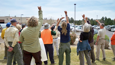
Heh heh, a new toy! Yep, now I can be a pest and take pictures—video too—of all things SAR. (Added later: This was a bit before cell phones had good cameras or maybe any cameras.) I'm photographically challenged, but I'll do my best to add some pizazz to my babbles from here on out with some images, though I'm sure, at times, it won't be possible—or right—to take pictures while on missions. Here, look, I think I figured out how to point and shoot:

That's the team, getting ready for some training earlier today, on line search and probability of detection. We had a good turnout—15 of us, I believe, including four from mounted with their horses.

Here's how it worked:
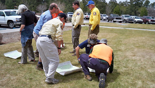
Yesterday, our team captain and other volunteers set up the course. They put out a bunch of five-gallon buckets, all painted brown to blend in with the surroundings. These buckets were spread out among the ponderosa pine, which is fairly open terrain but still littered with forest debris, rocks, and stumps, the latter resembling the buckets (or, rather, vice versa).
Behold Nelson and a bucket...

Today, we split into teams of three or four and, team by team, determined our critical spacing. That means an object roughly the same size as what we'd be looking for (in this case, it was an identical brown bucket) was set on the ground, and each person walked away from it to the point where they could still see the bucket and identify it as a bucket. We then counted our paces from that point back to the bucket. The average of each team's results was the critical spacing used for that team's line.
Now, using critical spacing usually means each person is twice that measured distance from the next searcher. That way, if the object is exactly between two people, it could still be seen. Critical spacing is affected not only by the size of the object—which, of course, could be as big as an unresponsive person or as small as a bullet—the terrain, the amount of brush, the weather, and so forth. Given the conditions and size of the objects today, our team's critical spacing turned out to be 30 paces, or roughly 90 to 100 feet, which meant searchers could be 60 paces, or about 200 feet, apart.
Given the size of the search area, however, and the number of people in our lines, we spread out at half critical spacing, or 30 paces apart (except for the mounted folks, who went two at a time, 60 paces apart). We all had radios in order to communicate rather than shouting down the line. We'd say, "Team 1, stop" or "Team 1, start," stating our team number first because there were other teams in the field, to start and stop our lines moving forward at intervals.
This photo shows the distance between me and my next teammate in the line, while another teammate paces off to his spot further out.

So, okay, each time a team member spotted a bucket, they would stop the line without pointing to the sighted bucket and write down the GPS coordinates of their current location, the direction of the bucket from their location using positions on a clock, and then their approximate distance from that bucket.
Sometimes, when the line stopped, other team members would spot the same bucket. Other times, the line would start up again, only to be stopped one step later when someone else spotted that or a different bucket. So it was stop and go, stop and go. We didn't know until we finished how many buckets were in the field.
I know, this sounds awfully thrilling, doesn't it? But I enjoy searching, not to mention the company of my teammates, and this was like a treasure hunt to me. It was also good practice for staying in our grid, keeping an eye on the person to our right and maintaining our spacing. That's much more challenging in more variable terrain and denser brush than we had today, though.
After the exercise, we all gave our notes to our coordinator, who's going to do some calculations and explain the results at our next meeting. Until then, I'm not really sure what kind of POD information he'll give us, but I'll let you know when he does.
So that was today's event. That and playing with my new camera and getting some news. Members of our team, along with the adjoining Yavapai County SAR team and others, have been searching on and off for more than two and a half years for a plane that disappeared in the Sedona area. That plane, flown by William Westover, a private pilot from Phoenix, with his passenger Marcy Randolph, has been found in a canyon in the Secret Mountain Wilderness. Here's the article from the Arizona Daily Sun: Plane wreckage identified.
Oops! There goes my pager! Gotta run...

That's the team, getting ready for some training earlier today, on line search and probability of detection. We had a good turnout—15 of us, I believe, including four from mounted with their horses.

Here's how it worked:
Yesterday, our team captain and other volunteers set up the course. They put out a bunch of five-gallon buckets, all painted brown to blend in with the surroundings. These buckets were spread out among the ponderosa pine, which is fairly open terrain but still littered with forest debris, rocks, and stumps, the latter resembling the buckets (or, rather, vice versa).
Behold Nelson and a bucket...

Today, we split into teams of three or four and, team by team, determined our critical spacing. That means an object roughly the same size as what we'd be looking for (in this case, it was an identical brown bucket) was set on the ground, and each person walked away from it to the point where they could still see the bucket and identify it as a bucket. We then counted our paces from that point back to the bucket. The average of each team's results was the critical spacing used for that team's line.
Now, using critical spacing usually means each person is twice that measured distance from the next searcher. That way, if the object is exactly between two people, it could still be seen. Critical spacing is affected not only by the size of the object—which, of course, could be as big as an unresponsive person or as small as a bullet—the terrain, the amount of brush, the weather, and so forth. Given the conditions and size of the objects today, our team's critical spacing turned out to be 30 paces, or roughly 90 to 100 feet, which meant searchers could be 60 paces, or about 200 feet, apart.
Given the size of the search area, however, and the number of people in our lines, we spread out at half critical spacing, or 30 paces apart (except for the mounted folks, who went two at a time, 60 paces apart). We all had radios in order to communicate rather than shouting down the line. We'd say, "Team 1, stop" or "Team 1, start," stating our team number first because there were other teams in the field, to start and stop our lines moving forward at intervals.
This photo shows the distance between me and my next teammate in the line, while another teammate paces off to his spot further out.

So, okay, each time a team member spotted a bucket, they would stop the line without pointing to the sighted bucket and write down the GPS coordinates of their current location, the direction of the bucket from their location using positions on a clock, and then their approximate distance from that bucket.
Sometimes, when the line stopped, other team members would spot the same bucket. Other times, the line would start up again, only to be stopped one step later when someone else spotted that or a different bucket. So it was stop and go, stop and go. We didn't know until we finished how many buckets were in the field.
I know, this sounds awfully thrilling, doesn't it? But I enjoy searching, not to mention the company of my teammates, and this was like a treasure hunt to me. It was also good practice for staying in our grid, keeping an eye on the person to our right and maintaining our spacing. That's much more challenging in more variable terrain and denser brush than we had today, though.
After the exercise, we all gave our notes to our coordinator, who's going to do some calculations and explain the results at our next meeting. Until then, I'm not really sure what kind of POD information he'll give us, but I'll let you know when he does.
So that was today's event. That and playing with my new camera and getting some news. Members of our team, along with the adjoining Yavapai County SAR team and others, have been searching on and off for more than two and a half years for a plane that disappeared in the Sedona area. That plane, flown by William Westover, a private pilot from Phoenix, with his passenger Marcy Randolph, has been found in a canyon in the Secret Mountain Wilderness. Here's the article from the Arizona Daily Sun: Plane wreckage identified.
Oops! There goes my pager! Gotta run...
Those Wonderful Search & Rescue Dogs

We do have a couple of search dogs on our own team—Cassie, our ground-tracking German shepherd, and Scout, an air-scenting brown Lab—but it's always a treat to meet others and see how they work.
Since Cassie joined our team about a year and a half ago, I've read some about SAR dogs, and I'm really interested in what they can do and how they're trained, though I doubt if I'd ever make that big commitment to become a handler. For one, I currently have a much-loved pup of 11 years, who'd not take kindly to sharing my attention. And once Sassy is no longer with us, I think it'll be a while before my husband and I own another dog (update: that turned out not to be true). Not with my plans for future multi-month thru-hikes and our intention to travel as extensively as possible. Someday, I'm sure we'll have another dog, but whether I'd want or be able to put in the time necessary to properly train a search and rescue canine would remain to be seen.
Anyhow, during our fieldwork this weekend, I enjoyed watching how each dog alerted differently during exercises. Some would bark, one would do circles (wing-dings, I call them), and another, a Weimaraner, basically body-checked her handler. They'd get so excited when it was time to work, which was usually communicated by their handlers putting certain collars, often with bells, or working-dog vests on them.
Also fascinating to me are the various commands and signals that pass between handlers and their dogs. For instance, one handler, Terry, explained to me that there's a difference between the command they give for a live person search and a search for a cadaver, and the dogs actually understand that difference. She explained that the dogs are "proofed" for certain animal bones so they ignore those of deer, elk, and other animals that aren't human. Terry and the others were gracious in answering the many questions my teammates and I pestered them with throughout the day.
Besides the treat of watching the dogs, it was also great to meet members of another SAR team as we sometimes do during big, multi-agency missions and at conferences. I enjoy learning about how they do things—sometimes quite differently than our own team—and what kinds of searches and rescues they've been on lately. I never get tired of the stories.
That's one reason I've put together the Search & Rescue Stories website, where I collect firsthand accounts by rescuers and the rescued and keep directories of websites for SAR teams around the world. I also participate on the SAR-L Discussion List, with topics ranging from techniques, training, and management to SAR tips, gear, news stories, and more. You can find a list of additional search and rescue online forums on my website in the "Articles & More" section.
Anyhow, other than some trainings lately, a litter-carry call that I hear was mostly handled by emergency medical personnel who were notified and quickly responded to the scene, and one 10-22'd call-out for a lost hiker who showed up just as we were loading gear at the SAR building, it's been relatively quiet for the past few weeks. Next weekend is the POD (probability of detection) and line search training, and then the three-day navigation "boot camp" begins on May 1st. The warming weather makes these activities much more enjoyable.
Subscribe to:
Posts (Atom)