My cell phone rang at 1 p.m. on Thursday, just as I was finishing lunch. "You available?" Al asked.
My adrenaline kicked in immediately. "You bet!" I told him and began gathering my gear while still on the phone. I admit, it feels good to be called before the pager has even gone off. Al said he needed someone to do nav/comm (to navigate and work the radio) while he would work with Cassie, his and the team's tracking dog.
This would be a search for an elderly woman (details omitted), who'd left the family's campsite that morning with her two dogs, but one dog had returned alone. Al needed to get to the staging area, where a scent article would be available, with Cassie as soon as possible and begin the hasty search. I quickly changed into field clothes and was out the door in five minutes.
After rendezvousing at the SAR building, then a stop at the Sheriff's office for a briefing, we were off toward Ashfork, down old (decaying) Route 66 and onto a rough dirt road to Stone Dam. A short while later, Cassie was in her harness and on her lead, and after a good sniff of the scent article, she and Al began working while I followed a short distance behind. I didn't want to distract Cassie or get in her way.
It was a good bit hotter at that lower elevation in the pinion-juniper than in Flagstaff. My mouth was dry within minutes, and my Gatorade was hot in no time, but I was in the zone, focused on our task, and didn't really notice the heat or the cactus barbs sticking through my trail runners.
While Al and I followed Cassie, weaving through thick brush along the south side of the lake, other field teams were heading out from base, some on foot and others on ATVs, calling the woman's name and searching for clues or prints, either those that might belong to the subject or the tiny dog she was with. We had no idea, of course, if the two were still together.
Cassie, a three year-old German shepherd, appeared very intent on her work, trying to find the scent, but she displayed "no positive alerts" during the hours that passed. At one point, we searched a narrow drainage, until a dropoff and thick brush prevented us from going further.
Al explained that it's easier for Cassie to follow scent in cooler temperatures—that it degrades faster in the heat. He was also unsure of the integrity, so to speak, of the scent article, which had been gathered by someone else before our arrival and mixed with a pair of boots.
After several hours of searching, we returned to base. Our intention was to leave Cassie there to rest after all that time in the heat and continue searching without her. But not long after we'd set down our packs for a short break ourselves, we heard over the radio that the subject had been found. What a relief! At her age and given the time since she'd last been seen, the heat, and lack of water, I was very concerned about the outcome. She was okay, though, and so was her dog. (I was worried about the chihuahua too!)
From what I understand, some of those programmable signs along the highway—you know, the kind that display road construction information or Amber alerts—had displayed a message about the missing woman, during which time a motorist saw that message, then spotted an elderly woman with a tiny dog along the road and reported it, and that led to our subject's rescue. Nice!
As the woman was reunited with family and our team reconvened and waited to debrief, I realized this had been one of the more costly missions I'd been on, personally speaking. You know that brand new camera I was so excited about? Gone. Yep, it's out there somewhere amongst the pinion-juniper. So if you happen to be out that way, doing some bushwhacking, and find a camera with some cool helicopter shots on it, let me know. If you wanna keep it, though, that's okay; my understanding and generous husband went out and bought me a new one with his own art supply fund after I'd called him, pouting, from the field. But no photos this time, I'm afraid.
At about 8 p.m., we arrived back at the SAR building and proceeded to unload all the unit gear and ATVs... JUST in time to head out for another mission.

These are my stories as a volunteer member of the Sheriff's Search and Rescue team in Coconino County, Arizona. I'll share what it's like to go from a beginner with a lot to learn to an experienced and, hopefully, valuable member of the team, as well as the missions, training, and other activities along the way.
Good SAR News And Bad SAR News
The good news first.
Yesterday, I included a link to an article about Ken Knight, editor of Backpacking Light Magazine, who was missing after going for a multi-day trek on the Appalachian Trail. Today, he was found alive and in good health after getting lost and starting a signal fire... which got a wee bit out of hand. You can read more and see a photo of Ken as he's being taken to a hospital to be checked out, on NewsAdvance.com out of Lynchburg, Virginia.
On the sad side of the day's SAR news—this story much closer to home—one of the three young people who were carried away by the swift Colorado River current in Grand Canyon was found deceased, and the other two are still missing. Here's the latest article from the Arizona Daily Sun: One Of Three Swept Away In Colorado Found Dead.
As far as our navigation boot camp class goes, today was map and compass day. I sat in on the classroom session, helping students now and then and refreshing my own skills at the same time, but was excused from the field work since we had more than enough instructors.
Tomorrow is the GPS class, a full day for me. So, tonight I'd better get some sleep. I had a heck of a time keeping my eyes open sitting in the classroom after just five hours of sleep last night. I spend way too much time on this computer.

Zzzzzzzzz... huh? wha?
Navigation Boot Camp & SAR News
First, a quick update: At the end of my last post, just as I was typing my final sentence, my pager went off. It was a call-out for a lost hiker in the Happy Jack area, which is approximately an hour outside of Flagstaff. Turned out to be one of those load up, drive, turn around, and unload missions. Air rescue located the lost woman, and then a deputy on the ground retrieved her before our team had left town. The only real excitement that night was that we witnessed part of a meteorite event, with reports coming into dispatch from all over the area, and it's possible one or more pieces hit the ground. We even heard air rescue say they'd been blinded by one of them.
(There's more "in the news" news at the end of this post, if you don't feel like reading my ramblings.)
Anyhow, this is day one of the three-day navigation "boot camp" our team is sponsoring, with members of other agencies along with some of our own teammates in the class. I was asked to be an assistant instructor, particularly during the field sessions or if someone needs one-on-one help during any of the classroom exercises.
Today's topic is alternative navigation (navigating without a compass or GPS), and tomorrow is map and compass. Sunday's class will be GPS.
Here are a few photos from today's class, and I'll explain what they're doing:
Instructor Art from our team jumped ahead with the curriculum at the beginning of the class, to get right to determining direction from the sun. He did this because the sun was fading fast as the day clouded up.
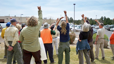 Above, you see students measuring one hand's width, starting from the sun's current location at the outer pinky edge of the hand to find due (true) south at the end of a comfortably extended thumb. It was around 11:30 a.m. at the time, and here in Flagstaff the sun is roughly at due south at 12:30 (though the actual range is between 12:15 and 12:40pm, depending on the time of year). So, being about one hour before "due south time" and each hand width being 15 degrees, or one hour of time in the sky, they measured one hand to the west. If it had been an hour past due south time or 1:30pm, they would have measured one hand width the other way, to the east.
 Once the students each determined true south, they were able to then orient their map (being sure to turn it so the bottom of the map was facing south, rather than turning the top—map north—toward the south by mistake.
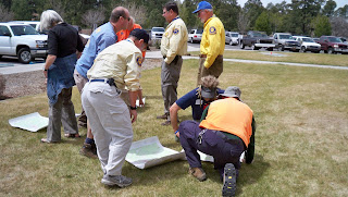
Once oriented, they could then determine a direction of travel by placing a pen on the map, one end on their current location and other other pointing toward their destination. (In this case, the latter was a random location for demonstration purposes.) Facing the body in direction of the pen, they would then be able to walk while keeping the sun in the same location relative to their body, at least for a time (because the sun moves... or the earth does relative to it, that is).
Without gadgetry, one could use various other methods of alternative navigation in conjunction with the map to travel to a particular point, comparing actual terrain to the features on the map, using terrain handrails, catch features, check points, and so forth. The key would be knowing your current location and finding it on the map to begin with.
 A little later in the class, Art discussed and then demonstrated how one can determine distance traveled, both by time and by pacing. In this photo above, students are counting paces over a distance of 100 feet, then repeating the process twice more and averaging their results. A single pace is either left-right-left=1 pace or right-left-right=1. In general, an adult takes 18 to 20 paces per 100 feet, or 1,000 paces per mile over "average" terrain. Go downhill and pace will lengthen. Uphill and pace will shorten. Of course, as Art explained, there are errors to these things, but those errors can be reigned in by using other techniques and information on the map.
One case where it would be helpful to have some kind of distance estimate would be when traveling across relatively flat, featureless terrain in the dark and the falling snow. In a scenario like that, it would be a good idea to have an idea of how far you've traveled in the event that the GPS you have malfunctioned. Some people prefer to use time to judge distance, but then you do have to account for any stops and know your average speed.
To keep track of distance by pacing, you can always keep ranger beads on a string or compass lanyard, moving one bead per 100 feet, or you can pick up a pebble or something similar every 100 feet.
So, that's a little of what went on in today's class, along with discussion about map reading, celestial navigation, and techniques for using terrain to one's advantage. This evening, the class will go out to the field to practice, taking turns using alt. nav. skills to move from point to point, partly in the daylight and then extending past dark.
Also, on other "in the news" notes, here are some links to articles about folks who are still missing and some who've finally been found:
Backpacking Light Editor Missing After A.T. Hike — An ongoing search in Virginia along the Appalachian Trail
Body of missing hiker found near Goblin Valley — About a woman who disappeared in the Canyonlands area of southern Utah five months ago
Canyon crews search for 3 missing in Colorado River — In Grand Canyon National Park (This just happened yesterday, and there's still no further news that I've found.)
And this is a REAL old one: A Mystery of the West is Solved — Remains of Everett Ruess found!
(There's more "in the news" news at the end of this post, if you don't feel like reading my ramblings.)
Anyhow, this is day one of the three-day navigation "boot camp" our team is sponsoring, with members of other agencies along with some of our own teammates in the class. I was asked to be an assistant instructor, particularly during the field sessions or if someone needs one-on-one help during any of the classroom exercises.
Today's topic is alternative navigation (navigating without a compass or GPS), and tomorrow is map and compass. Sunday's class will be GPS.
Here are a few photos from today's class, and I'll explain what they're doing:
Instructor Art from our team jumped ahead with the curriculum at the beginning of the class, to get right to determining direction from the sun. He did this because the sun was fading fast as the day clouded up.
 Above, you see students measuring one hand's width, starting from the sun's current location at the outer pinky edge of the hand to find due (true) south at the end of a comfortably extended thumb. It was around 11:30 a.m. at the time, and here in Flagstaff the sun is roughly at due south at 12:30 (though the actual range is between 12:15 and 12:40pm, depending on the time of year). So, being about one hour before "due south time" and each hand width being 15 degrees, or one hour of time in the sky, they measured one hand to the west. If it had been an hour past due south time or 1:30pm, they would have measured one hand width the other way, to the east.
  Once the students each determined true south, they were able to then orient their map (being sure to turn it so the bottom of the map was facing south, rather than turning the top—map north—toward the south by mistake.
 Once oriented, they could then determine a direction of travel by placing a pen on the map, one end on their current location and other other pointing toward their destination. (In this case, the latter was a random location for demonstration purposes.) Facing the body in direction of the pen, they would then be able to walk while keeping the sun in the same location relative to their body, at least for a time (because the sun moves... or the earth does relative to it, that is).
Without gadgetry, one could use various other methods of alternative navigation in conjunction with the map to travel to a particular point, comparing actual terrain to the features on the map, using terrain handrails, catch features, check points, and so forth. The key would be knowing your current location and finding it on the map to begin with.
 A little later in the class, Art discussed and then demonstrated how one can determine distance traveled, both by time and by pacing. In this photo above, students are counting paces over a distance of 100 feet, then repeating the process twice more and averaging their results. A single pace is either left-right-left=1 pace or right-left-right=1. In general, an adult takes 18 to 20 paces per 100 feet, or 1,000 paces per mile over "average" terrain. Go downhill and pace will lengthen. Uphill and pace will shorten. Of course, as Art explained, there are errors to these things, but those errors can be reigned in by using other techniques and information on the map.
 One case where it would be helpful to have some kind of distance estimate would be when traveling across relatively flat, featureless terrain in the dark and the falling snow. In a scenario like that, it would be a good idea to have an idea of how far you've traveled in the event that the GPS you have malfunctioned. Some people prefer to use time to judge distance, but then you do have to account for any stops and know your average speed.
To keep track of distance by pacing, you can always keep ranger beads on a string or compass lanyard, moving one bead per 100 feet, or you can pick up a pebble or something similar every 100 feet.
So, that's a little of what went on in today's class, along with discussion about map reading, celestial navigation, and techniques for using terrain to one's advantage. This evening, the class will go out to the field to practice, taking turns using alt. nav. skills to move from point to point, partly in the daylight and then extending past dark.
Also, on other "in the news" notes, here are some links to articles about folks who are still missing and some who've finally been found:
Backpacking Light Editor Missing After A.T. Hike — An ongoing search in Virginia along the Appalachian Trail
Body of missing hiker found near Goblin Valley — About a woman who disappeared in the Canyonlands area of southern Utah five months ago
Canyon crews search for 3 missing in Colorado River — In Grand Canyon National Park (This just happened yesterday, and there's still no further news that I've found.)
And this is a REAL old one: A Mystery of the West is Solved — Remains of Everett Ruess found!
Subscribe to:
Posts (Atom)