(There's more "in the news" news at the end of this post, if you don't feel like reading my ramblings.)
Anyhow, this is day one of the three-day navigation "boot camp" our team is sponsoring, with members of other agencies along with some of our own teammates in the class. I was asked to be an assistant instructor, particularly during the field sessions or if someone needs one-on-one help during any of the classroom exercises.
Today's topic is alternative navigation (navigating without a compass or GPS), and tomorrow is map and compass. Sunday's class will be GPS.
Here are a few photos from today's class, and I'll explain what they're doing:
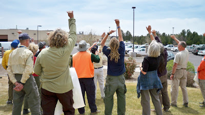
Instructor Art from our team jumped ahead with the curriculum at the beginning of the class, to get right to determining direction from the sun. He did this because the sun was fading fast as the day clouded up.
 Above, you see students measuring one hand's width, starting from the sun's current location at the outer pinky edge of the hand to find due (true) south at the end of a comfortably extended thumb. It was around 11:30 a.m. at the time, and here in Flagstaff the sun is roughly at due south at 12:30 (though the actual range is between 12:15 and 12:40pm, depending on the time of year). So, being about one hour before "due south time" and each hand width being 15 degrees, or one hour of time in the sky, they measured one hand to the west. If it had been an hour past due south time or 1:30pm, they would have measured one hand width the other way, to the east.
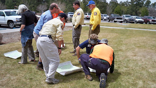
  Once the students each determined true south, they were able to then orient their map (being sure to turn it so the bottom of the map was facing south, rather than turning the top—map north—toward the south by mistake.
 Once oriented, they could then determine a direction of travel by placing a pen on the map, one end on their current location and other other pointing toward their destination. (In this case, the latter was a random location for demonstration purposes.) Facing the body in direction of the pen, they would then be able to walk while keeping the sun in the same location relative to their body, at least for a time (because the sun moves... or the earth does relative to it, that is).
Without gadgetry, one could use various other methods of alternative navigation in conjunction with the map to travel to a particular point, comparing actual terrain to the features on the map, using terrain handrails, catch features, check points, and so forth. The key would be knowing your current location and finding it on the map to begin with.
 A little later in the class, Art discussed and then demonstrated how one can determine distance traveled, both by time and by pacing. In this photo above, students are counting paces over a distance of 100 feet, then repeating the process twice more and averaging their results. A single pace is either left-right-left=1 pace or right-left-right=1. In general, an adult takes 18 to 20 paces per 100 feet, or 1,000 paces per mile over "average" terrain. Go downhill and pace will lengthen. Uphill and pace will shorten. Of course, as Art explained, there are errors to these things, but those errors can be reigned in by using other techniques and information on the map.
 One case where it would be helpful to have some kind of distance estimate would be when traveling across relatively flat, featureless terrain in the dark and the falling snow. In a scenario like that, it would be a good idea to have an idea of how far you've traveled in the event that the GPS you have malfunctioned. Some people prefer to use time to judge distance, but then you do have to account for any stops and know your average speed.
To keep track of distance by pacing, you can always keep ranger beads on a string or compass lanyard, moving one bead per 100 feet, or you can pick up a pebble or something similar every 100 feet.
So, that's a little of what went on in today's class, along with discussion about map reading, celestial navigation, and techniques for using terrain to one's advantage. This evening, the class will go out to the field to practice, taking turns using alt. nav. skills to move from point to point, partly in the daylight and then extending past dark.
Also, on other "in the news" notes, here are some links to articles about folks who are still missing and some who've finally been found:
Backpacking Light Editor Missing After A.T. Hike — An ongoing search in Virginia along the Appalachian Trail
Body of missing hiker found near Goblin Valley — About a woman who disappeared in the Canyonlands area of southern Utah five months ago
Canyon crews search for 3 missing in Colorado River — In Grand Canyon National Park (This just happened yesterday, and there's still no further news that I've found.)
And this is a REAL old one: A Mystery of the West is Solved — Remains of Everett Ruess found!
