About Coconino County

About Coconino County

Encompassing 18,661 square miles, Coconino County, Arizona, is the second largest county in the U.S. but one of the least populated. Our county includes Grand Canyon National Park, the Navajo, Havasupai, Hualapai and Hopi Indian Reservations, and the largest contiguous ponderosa pine forest in the world. Elevations range from 2,000 feet above sea level along the Colorado River to 12,633 feet at the summit of Mt. Humphreys in Flagstaff.

Disclosure: Some of the links on this site are affiliate links, and I may earn a commission if you click through and make a purchase.

SAR While I Was Away

While I know our SAR coordinator and assistant coordinators have been plenty hard at work, in part with calls that ended up being resolved by deputies and means other than us volunteers, it has been rather slow when it comes to call-outs. Not that that's a bad thing, of course! But there have been some call-outs lately, all of which occurred while I was either in a SAR-related class (Incident Command System 300) or while I was away for eight blissful days at Yosemite National Park.

First, there was the call for another body recovery below Midgley Bridge in Sedona. I say "another" because, sadly, we tend to have several of these calls each year. All but one that I know of since I've been on the team have been suicides, while one near (but not under) the bridge was an accidental fall. In this latest case, it was a 60-year-old woman who had died. See Woman's Body Found Below Midgley Bridge in the Arizona Daily Sun. Several of my teammates responded to this call.

Little Colorado River Gorge
Then there was a technical rescue call for a young man who'd fallen into the Little Colorado River Gorge and broken his leg. After a long wait due to the remoteness of the area and some misinformation from the reporting party about the victim's location, the injured man was eventually short-hauled by helicopter to the rim and then flown to the hospital. 

As I was on my way back from the Yosemite trip, a SAR call came through about a missing mule-rider in the Schultz Pass area of the San Francisco Peaks who may also have been injured. The call was for both general (ground) and mounted SAR. I later found out that the missing party showed up at home on his own.

After returning home myself, I happened upon a news story stating that search and rescue volunteers and deputies had been sent to look for a self-reporting lost hiker on Mount Elden, who told the 9-1-1 dispatcher that he'd hurt his ankle and thought he was being stalked by wild animals. Since I never received a call-out message, I'm assuming that certain volunteers who live near Mt. Elden were called directly to make the initial response. Read Drunken Hiker Asks for Rescue to find out how that mission was resolved.

And that's about all the SAR volunteer activity I know of, other than some team trainings, while I was away. In about a week, I'll be tied up again, this time in a five-day Inland Search Management class. Having completed the ICS-300 class last month and some other prerequisites, I've now been added to the ops list and will be called out if operations leaders are needed to prepare for a mission. So, this next class will teach me more about SAR operations and help me contribute. I'm excited! 

Have I mentioned lately that I love SAR?


Time to Learn Some SAR Ops


Now that I'm in my fifth year with Coco SAR, I'm eligible to begin training for SAR ops (ops = operations). I'm pretty excited about this because I love that part of search and rescue. I look forward to helping with things like mapping out and planning a search, allocating resources and personnel, directing SAR members as they show up for a mission as to what needs to be done and what gear needs to be loaded, and assisting with whatever else the coordinator might need when preparing for a mission.

On Tuesday, March 13–15, I'll be taking the Intermediate Incident Command System (ICS) class, which will cover topics such as transfer of command, unified command functions in a multi-jurisdictional or multi-agency incident, ICS forms, resource management, inter-agency mission planning and procurement, and ICS staffing and organization to include reporting, working relationships and information flow.

******

The way it's working these days with our team is that, when the coordinator is contacted about a SAR call, he'll do some initial investigation and then, if necessary (depending on the type of mission it is), call out just those members qualified to help with operations. Whichever "ops leaders" are available at that stage respond to the SAR building to assist. Then, when ready, the coordinator will do a general call-out for the rest of the team, just the technical rescue team, or even specific members with specific skills as the situation may warrant.

Other than the paid coordinators, SAR ops folks are all volunteer members of team. Many are also members of the tech team, and one or two are mounted unit members. Some of those who help with ops have been on the team for many years—more than 25 years in one case—and have taken many different operations courses. I'm looking forward to that type of training, myself.

Sometimes, ops leaders and the coordinator are able to resolve a situation, often with the help of deputies on scene or over the phone with a lost subject, before a general call-out is made, so other volunteers are able to keep doing what they're doing (like sleeping, for one thing) and don't know about the situation until it's discussed at a monthly meeting. It's amazing how many times the coordinator has been "just about to push the button" for a general call-out when the subject has been located or assisted back to safety or a known location by phone. That saves the rest of us a lot of interrupted activities and unnecessary responses. Saves money too, not to mention time for the person/s who needed help in the first place.

Want to know more about Incident Command System training? These classes are part of FEMA's National Incident Management Training Program. Visit the FEMA NIMS Training site.


A Joint Technical Rescue Training with Border Patrol

That was fun! And it was a challenging exercise, too.

Members of Borstar (which stands for Border Patrol Search, Trauma, and Rescue) out of Tucson invited our technical rescue team to join them for some training in Sedona. They'd come up from southern Arizona on Tuesday to work on wilderness survival and high-angle rescue skills, setting up camp in a beautiful spot overlooking red rock country.

On Wednesday morning, those of us from Coconino County Sheriff's Search and Rescue who were available to participate drove down to meet them, and after introductions were made around their morning campfire and breakfast and coffee were consumed, we moved to the site of the day's tech training: the canyon at Midgely Bridge.

The goal for the day was to set up a high line across the canyon, then do some evolutions with a rescuer on the line, sending that brave soul out to the middle of the canyon, lowering and then raising the rescuer, and then hauling him or her back to one side of the canyon or the other. (I heard some onlookers refer to what we were setting up as a "zip line," but that's something quite different. We certainly didn't want to send anyone zipping anywhere.)


The first part of the operation was a real challenge, given that we didn't have one of those guns that shoots rope. (I've not seen one in action yet, but I've heard about this piece of equipment several times—every time we have to haul rope from one side of a canyon to another.) Once the rope, the track line, had been secured on the "near side" of the canyon, a Borstar member rappelled to the bottom, brought the rope across, and hooked it up to a line sent down from the "far side," so the other end of the rope could be raised and anchored over there. Problem was, there were trees in the way, and the rope had to clear those trees. And it was a lot of rope. The canyon was just shy of 300 feet from rim to rim.

No one was in a big rush, but it took quite a long time just to get the rope strung across the canyon. Then came the task of setting up the anchors, the artificial high directionals on both sides, the tag lines, and the hoist line. Issues were discussed (i.e., the angle of the monopod and guiding lines), and the teams on either side hiked around to the opposite rim via the bridge to inspect the other team's setup before any evolutions took place.

Finally, it was time to send someone across, down, up, and over. Some challenges were had along the way, but in the end, everything was done safely and successfully.

Here are some more photos from our fun day of training. (Some of my teammates went back to Sedona for a second day of joint training with Borstar.)...

One of my teammates helps Borstar members put together the monopod.

Getting some good shots of the system.

Putting together the final touches, like the big Kootenay pulley on the track line.

A rescuer is sent out over the canyon.

The rescuer is lowered mid-canyon, then raised and hauled to the other side.


A Happy Surprise in Waterholes Canyon


Once upon a time, there was a man in a canyon. Well, not just in a canyon, stuck in a canyon. This was a very deep and narrow canyon, and the man had been stuck down there for four days and three nights. Three very cold nights, that is, with little to protect him from the elements but a thin jacket and leaves he stuffed in his shirt. A winter storm had visited the area while he was down there, alone.

The man, a traveler from Europe, had run out of water in his Camelbak, probably on the first day. He had no food. He'd injured his left ankle, which was severely swollen, and had bad rope burns on his hands. By the fourth morning, he'd given up hope and "made peace," he later said. He knew he would not survive another night.

But he did! Thankfully, the cards were in his favor, as was his own strength, so he spent that fourth night in a warm bed instead of freezing, thirsty, hungry, and possibly dying in that canyon.

The man had entered the canyon on Friday. His flight home left from Las Vegas without him on Saturday. (Good thing it was that soon because no one may have realized he was missing until he missed that plane.) On Sunday, his wife had called for help when her husband failed to return, and that call for help was relayed to the Coconino County Sheriff's Department.

In the wee hours of the morning on Monday, the man's vehicle was located at the top of the slot canyon, in a pull-out along the highway south of Page, Arizona. The search and rescue team was called out at about 4 a.m., and north we went from Flagstaff. It didn't look good for the man we had to assume was somewhere in that big canyon, with many rappels, one about 400 feet in vertical length, between the highway and the Colorado River.

But then things took a turn... for the much better: A deputy walking the rim and calling out in the dark heard a voice answer from below. That great news was quickly relayed to our team as we drove, and the mood changed. Approximate coordinates were called in by the deputy on scene to our coordinator in another vehicle and transmitted from our coordinator to us.

Then our teammate in the passenger seat, an expert canyoneer very familiar with this canyon, plotted those coordinates on the map, knowing it was not possible to pinpoint the man's exact location by voice contact alone. Given a good idea of where he was, however—although he could have been at the top of a rappel or at the bottom—rescue scenarios were hashed out and re-hashed among us. Everything would depend, of course, on the man's actual location in the canyon and his physical condition.

The rescue could not have gone more smoothly. Two of my teammates and a medic from Page Fire Department entered Waterholes Canyon via a known "escape route" not far from where voice contact had been made from the rim. Carrying medical and warm-up gear, extra food and drinks (including some water I'd boiled for hot cocoa), they made their way down and then up-canyon toward the subject.

Meanwhile, the rest of us came up with a backup plan in case the man needed to be raised out of the canyon with a technical rope rescue system. The DPS helicopter had landed, and the pilot and medic stood by.

Regarding the helicopter crew, they'd flown over the canyon and spotted the man, but they would not have been able to short-haul him from his current location. The canyon was too deep and narrow. And given the fact that the man was standing and waving his arms, the added risk of performing a short-haul, had one even been possible, was deemed unnecessary. The man would either be assisted out by rescuers under his own power, or he would be "packaged" in either a litter or a harness and raised out of the canyon with an attendant.

As it turned out, the man, perhaps somewhat aided by adrenaline, was able to tough out his injuries and exit the canyon via the escape route, with the help of the three rescuers. As his head popped up over the rim, we all saw a big smile on his face, and we all smiled, too.

Joel and Mike get geared up and ready to go into the canyon.

Jeff from Page Fire looks down at the deputy on the rim.

Rescuers wait for word from those descending to the subject.

DPS Ranger out of Tucson arrives on scene.

Our team's Polaris UTV with Mattrax is very useful in this rugged terrain. 

******

 And in other recent Coconino County Sheriff's Search and Rescue news...

There was a mission in Meadow Canyon, a moderately technical canyon south of Flagstaff. This was a search for two overdue canyoneers. (Canyon rescues seem to be... rather, I would say are on the increase in the area.)  I was unable to respond to this call, which came in the middle of the night, because I couldn't leave my sick pup (who's now fine, thankfully). But a teammate gave me the scoop. He said...

"I went on that call last night thinking it would last maybe 6 to 8 hours (I had a job lined up at noon) and instead it lasted 16 hours. A couple guys in their early 40s were overdue from a canyoneering trip. Eight of us tried all night to find roads that would take us to the edge of the canyon but with no luck. The back roads were muddy, icy and snow covered.

"The helicopter saw the subjects' campfire and got their coordinates, but we still couldn't get to them. With daylight, a radio was dropped to them and they claimed they were too tired and cold to go further and were afraid of the almost 100-yard swim in from of them.

"We talked about sending two people in by helicopter to help swim and hike them out but opted instead for a short haul. The chopper was low on fuel, so the subjects were flown just to the rim, and we had to pick them up via UTV and ATV. The road was strewn with boulders, mud and snow, and it took a couple of hours. On the way back, the ATVs got stuck in the snow a number of times. It was a long day, but the subjects were very thankful."

So, good, another happy ending! 

******
Need a new read? My novel "I. Joseph Kellerman" (which has nothing at all to do with SAR) is available on Amazon Kindle and in paperback. Thanks for putting up with my blatant plug.

Being a K-9 Backer -- A Search Near Wapatki

View of the San Francisco Peaks from Wapatki National Monument

The first call-out happened not long after I'd gone to bed. It was sleeting, and the roads were icy. Earlier that evening, I'd been reading online about lots of accidents in the area, and I knew my car was not adequate for driving in those conditions. So, I decided to stay home. That's never an easy decision for me.

At 5:45 the next morning, another call-out came through for a second operational period. The missing person hadn't been located during the hasty search overnight. Knowing I really didn't want to miss another call, my boyfriend kindly offered to drive me to the SAR building in his truck. Good thing because the roads were still very icy.

As I was getting ready for this winter weather mission, my phone rang again. It was our K9 handler, Cindy, asking if I'd be her backer as I've done a number of times now. I didn't hesitate. I really enjoy working with Cindy and her dogs. We'd meet at the SAR building and head out to the search area as quickly as possible, before the rest of the team, to get a head start so the dogs could do some searching before there were additional humans and their scents in the area.

When I'm backing the K9 team, I'm responsible for navigation and radio communication while I help Cindy keep an eye on the dogs (she often uses all three of her current search dogs at the same time) and do my own searching, too.

I also help Cindy decide the best way to search our assigned area. Sometimes, the Incident Commander asks us what we think the best area and search strategy would be, so we put our heads together and hash out ideas, taking into account wind direction (related to the dogs' ability to scent a subject), terrain, and what we know about the missing person's actions and the point last seen (PLS).

In this case, we were searching for a missing woodcutter. He'd disappeared around 4:30 p.m. the day before, walking away from his two companions during very cold and windy conditions. It had gotten even colder with precipitation overnight. The other two men, who hadn't seen their friend's direction of travel when he wandered away, stayed in the area for a while, searching, then left and called for assistance.

So, we knew basically where to begin—the general area along a Forest Service road on BLM land, just outside of Wapatki National Monument—but not a specific point. No footprints had been found by trackers during the overnight hasty search, so we still had no direction of travel. The area is mostly cinder-covered with lots of pinon pine and juniper (much more than what's shown in the photo above). Cindy and I noted that our own footprints were very clear in the cinders, so we knew that the subject's would be as well.

Cindy tested the wind direction with her little bottle of baby powder. She does this frequently as we search with the dogs, since wind direction can change quickly. We also discussed where to search and what to use as boundaries in this very open area. We noted power lines both on the map and in the field, along with two-track roads we could use. We would also use random GPS coordinates to create the area for our grid search.

At this point, given what we knew, we agreed that walking tight grids would be best, in case the subject were unresponsive (i.e., due to hypothermia or worse).

As we were getting our packs together and putting the harnesses with GPSes on the dogs, word came over the radio that the missing subject had just called a family member on his cellphone, saying he was very cold and trying to walk toward Wapatki Road. He was alive! Unfortunately, the phone call was dropped and no further contact had been made. Cell service was very sketchy out there, and I had none at all.

Wapatki Road surrounds the area in a big loop. So, the subject could have been walking in any direction toward this "catch feature." And we still had no idea where he was, so his distance from the road could potentially have been a very long way. But now that we knew he was alive and moving, Cindy and I agreed to make our grid passes with the dogs much wider.

Based on wind direction and given the area the DPS helicopter had been flying over as we'd been en route and getting ready, we decided on the area we'd search. We got moving at a pretty good clip, the dogs running and weaving, working excitedly. Cindy and I called and whistled for the subject as we watched the dogs for any sign they were working scent.

I glanced at my GPS now and then, to make sure we were making relatively parallel grids, letting Cindy know if she should angle a bit more to the left or right. I stayed a bit behind her and several paces to her side, keeping downwind of the dogs so my scent wouldn't interfere. I also let Cindy know when it was time to turn around for the next pass.

After about two hours of searching in long, wide grids and yelling and whistling, I called in to base. We'd not heard any radio traffic for a long while. Had any additional contact been made with the subject? Were the other searchers in the area yet?

As a matter of fact, the reply was: "The subject has been located. You can return to base."

It was a lengthy walk from our current location back to our vehicle, and I now noticed how tired I was from walking on cinders. (I don't notice fatigue as much when I'm actually searching.) The dogs, though, were still full of energy and still searching for human scent on the way back. To them, it's all a fun game.

When we met back up with IC, we learned that the subject had been found along a Forest Service road (not the paved Wapatki Road) a good distance away from the area we'd been searching and in a direction the dogs could not have detected his scent on the wind. Still, we felt we'd done the best we could and made a good strategy decision based on what we'd known, which wasn't much, when we'd begun searching. Cindy and I were glad we'd had a chance to work together again.

Recent SAR Activity

I haven't posted in awhile, but that's not for lack of SAR activity. Although it's been slower than last year at this time when it comes to call-outs, there have been missions lately. It's just that, unfortunately for a writer-type like me, there have been a couple of recent missions I've participated in that I'm not able to write about due to their ongoing and, you might say, legally sensitive nature.

But... I can tell you about a few other missions, none of which I've been able to respond to myself. Two of those calls happened Wednesday, as I sat here with a nasty head cold and sore throat. Woe is me. So, my teammates filled me in...

A Bitter Cold Search on the North Rim

This search occurred a few days before Christmas. The call-out, which came at 3 a.m., was about a track hoe driver who didn't return from moving his machine from one area to another near the North Rim of Grand Canyon.

Searchers towed the team's snowcat and four snowmobiles a few hours from Flagstaff to Jacob Lake and then another 20 miles toward the Grand Canyon on Highway 67. They stopped at a side road the missing subject was reportedly on and sent in the 'cat, with the snowmobiles on standby. In about a mile, the 'cat found the track hoe with the driver inside, cold but otherwise in good shape. He had gotten low on fuel and stopped after midnight.

SAR volunteers were then told two of the subject's fellow employees had taken a Jeep to go look for him, so when the DPS helicopter arrived on scene, our coordinator directed the aircraft to look for their vehicle. The crew spotted the unoccupied vehicle and one subject a few miles away, walking toward the track hoe, so SAR volunteers in the snowcat went back in and picked him up. Turns out, he was the only one in the Jeep. 

It was bitterly cold out there, below zero with the wind chill, so searchers were glad to wrap things up.


A Joint Search for a Missing Hiker in Yavapai County

At 6 a.m. on the morning of Wednesday, December 28th, our technical/mountain rescue team was called to assist the Yavapai County team with a search for an overdue 21-year-old hiker, last seen on Tuesday at around noon in steep, rugged terrain near the Village of Oak Creek.

That hiker was Mahdi Harrizi, visiting the area with his family from New York. Mahdi's mother called for help at about 4 p.m. on Tuesday, after her son called her from his cellphone, saying he was stranded on a ledge near Castle Rock.

According to reports, Mahdi had taken a trail from behind the resort where they were staying. At the time his mother made the call for help, she had been able to see him up at the top of the mountain.

Searchers from Yavapai County arrived on scene soon after, just as the sun was setting, but Sheriff's deputies were unable to get a GPS coordinate on Mahdi's cell phone because of the remote location. Ground searchers and a Department of Public Safety helicopter crew looked for Mahdi throughout the night and then called Coconino County SAR for assistance.

From what I heard, just after the DPS helicopter dropped off more technical rescue SAR members at the top of the mountain at about 11:15 a.m. on Wednesday and were flying off, the crew spotted Mahdi's body between a sheer cliff and some shrubs. Sheriff’s officials stated that Harrizi apparently fell about 150 feet, and he may have fallen shortly after his conversation with his mother.

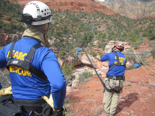
Here's a photo from one of my teammates who was at the top of the mountain....


From One Mission to Another

At 4 p.m. on the 28th, we received another call-out. This was another mission down in Sedona for a stranded climber. Additional technical rescue team members as well as general SAR were asked to respond, to assist the other tech team members already en route from the day's first mission to the next.

I don't yet have any details about what happened, but I'll fill in you once I do.

And now that I'm just about over this creeping crud I've had for several days, I've got my SAR gear ready to respond if... well, when we get another call.

Coconino County SAR Celebrates it's New Home


On Saturday, December 10th, a gathering of search and rescue volunteers, Sheriff's Office personnel, folks from the Department of Public Safety, Guardian Medical Transport, local fire departments, the Park Service and Forest Service, Sheriff's Posse volunteers, members of the County Board of Supervisors, friends and family and members of the public celebrated the Grand Opening of the new Coconino County Sheriff's Search and Rescue facility, which is located behind the law enforcement complex in Flagstaff.

This new building houses all of our team's SAR equipment, including our technical rescue gear, snow and ice and medical equipment, a fleet of snowmobiles and ATVs, a snow cat and other search and rescue vehicles, communications equipment, water rescue equipment, and more.

The facility now also brings our meetings, trainings, and coordination under that same roof. This means more efficiency and even faster response times, since the team will no longer be operating between this new building and the main law enforcement building across the parking lot.

According to yesterday's article in the Arizona Daily Sun, construction on the new search and rescue facility began back in 2004, when the pavement was first poured. But that construction stalled soon afterward when financing dried up, and the actual structure wasn't completed until 2008. At that time, our team was able to move the equipment from its long-standing location on the east side of town at the county yard to the new west-side facility, making our response to call-outs more convenient for most of us.

From that point until just a few days ago, however, we'd been operating out of a shell of a building, with our coordinator and map-printing capabilities over in the Sheriff's Office, which meant that preparing to deploy for a mission was what you might call a fragmented operation. Not so any longer, thanks to additional funding of this project by the County Board of Supervisors, enabling the completion of the administrative side of the building. There's still work to be done, including the installation of a sixth bay door, a mezzanine, a climbing wall for training, and the paving of the exterior parking area, but that will happen over time.

On Saturday, SAR members were on hand to answer questions about our equipment, including a new Humvee from the Arizona National Guard, and our training program. Lunch was followed by comments from Sheriff Bill Pribil, members of the Board of Supervisors, and our team captain, Andrew Moore, and then a ribbon-cutting ceremony.

Here are some photos from the event...

The new sign

Our snow cat, some quads, and our new Hummer in the back

A gift from the National Guard

The huge bay where we store team equipment and vehicles.

Technical rescue and snow & ice equipment (and a rescue dummy)

The new communications room

The new meeting and training room with flat screen monitors

The kitchen, for events and to feed volunteers during big incidents

Our team captain cuts the ribbon as the Sheriff and many others look on


A Passing Motorist Brings a Search to a Close

The man we were looking for had been missing for three days, having failed to show up at a prearranged rendezvous time after another of his many camping and "walkabout" trips in this area he knew well. I know I wasn't alone in my assumption that he wasn't "just" lost.

Hypothermia was a possibility. It had rained some in the past couple of days, and the subject apparently wasn't well prepared for the cold, wet weather. Injury was another possible scenario, as was a potential miscommunication with the family member who'd gone back to get him on Saturday. Based on information we were given in our briefing prior to starting the search, we had reason to believe this may have been the case—that he had decided to stay out there longer but failed to contact his ride about his change of plans. Given the weather, though, and the fact that he wasn't properly equipped, our SAR coordinator decided to call out the team to look for him sooner than later.

The subject had also made prior statements about taking his own life, so that too was on our minds.

We had been divided into teams of two, in this case one experienced member with one new member as the split was pretty much down the middle. It was good to see so many new SAR teammates from the latest academy come out for the search.

We were all in or on vehicles—SUVs, trucks, quads, and the UTV—slowly driving unpaved roads and two-tracks, looking for the missing man's campsite and any other clues that might be associated with him, not to mention the man himself. We'd been told he preferred to stick to walking roads as opposed to traveling cross-country, so that's what we were starting with.

As always, we were scanning the landscape and looking for any sign of tracks or clues, hoping to get a direction of travel. The team did find a number of things—the campsite, prints, a jacket—which turned out to be related to our subject.

But the search lasted only a couple of hours from the time we reached the area and deployed. A 9-1-1 call from a motorist on westbound I-40 about 21 miles east of Flagstaff, several miles from where we'd begun our search at the man's last known location, reported seeing what she thought was a body hanging from a billboard. It was difficult to see from the highway, so I'm thinking the person who spotted the lower portion of the man's body behind the billboard was an observant passenger.

Soon, Sheriff's deputies and SAR personnel confirmed the body as that of 39-year-old Stephen Dale Sterling, bringing our search to an end. See the story in the Arizona Daily Sun.


Searching for Justin


With my left set of fingertips gripping a tiny, sharp ridge of (hopefully) embedded volcanic rock above me, my left foot perched on a small piece of (hopefully) embedded rock below, and my free hand and foot groping for something solid, I tentatively glanced down over my left shoulder. I decided there was no way I could safely go back the way I'd just come up, and I was doubtful about moving on.

The steep wall of the canyon was covered in loose cinder, and I couldn't know for sure if the pieces of rock I wasn't quite able to reach were loose or solidly attached. Judge incorrectly or make a wrong move, and I was going for a fast ride down that cinder slide and over that ledge down there. That's what I was envisioning, anyway.

Crap. Not the kind of pickle I want to find myself in. And my two more confident teammates knew it. Every other word of mine was a bad one at that point.

So, you see, we'd completed our assignment, having been inserted into the Little Colorado River gorge by helicopter several hours earlier, exiting the DPS aircraft as the rotors continued to spin and kick up sand. We'd searched the far side of the river, which was flowing pretty well at the time, overlapping the point where another team had been inserted further upstream.

We then forded the river at a wide, shallow (and slippery) area, and searched the opposite bank back the way we'd come. We'd been careful to look at piles of river debris from past flooding and kept an eye on the mud and shallow parts of the river for anything unusual that might be sticking out. We'd searched the shores, including small caves and crevices and vegetation that could potentially catch and hide human remains.


We were looking for any sign of 40-year-old Justin Brian Hall, an avid outdoorsman, former Appalachian Trail thru-hiker, and climber, who'd disappeared from a friend's home where he'd been house-sitting in the very rural area near Sheba Crater and the border of the Navajo Reservation more than a month earlier.

This was a continuation of the ongoing search, which had already extensively covered a one-mile radius around the house and well beyond, following up on tips and suggestions from locals and Justin's family and friends. Nothing at all had turned up that would indicate a destination or direction of travel.

This is the house where Justin had been staying....


Now searching about 10 miles (as the crow flies) from Justin's last known location, where his vehicle and belongings remained, ground teams were covering several miles along the Little Colorado River. A K9 team, with me as one of the backers, had already searched the area just below and partway up Grand Falls at an earlier date, but it was being searched again on this day.

We were looking not only for human remains but possibly a couple of items believed to be in Justin's possession at the house but yet were unaccounted for, as well as any type of clue or sign that could potentially be linked to him. We found nothing.

Here are a couple of photos from our earlier search at Grand Falls with the dogs....


This is us searching partway up the falls, on a ledge.


Today, by the time our field team of three returned to where we'd been dropped off at the bottom of the canyon several miles downstream from Grand Falls, the DPS crew had been reassigned and left the area. So, our options were to climb out on our own or... yeah, that was about it. We could do that either somewhere near where we were or turn around and hike all the way back to Grand Falls, where we knew there was a trail to the rim. Or perhaps find a good place to climb out along the way.

We chose to find a route near where we were, but, looking up, it was difficult to tell how it would go. For the most part, the climb turned out to be steep (obviously), and the rocks and sparse vegetation were sharp, but it was otherwise okay... except for a couple of spots, like the one I described above, where I was temporarily frozen. And stopping one's momentum in sketchy spots doesn't exactly help matters. I could feel myself slipping every second I stayed in place.

Thankfully, my teammates stationed themselves in spots below and above me, which gave me just enough confidence to move from those precarious locations. After anchoring himself as best he could, one of my companions offered me an outstretched wrist to reach for in case I needed it (which thankfully I didn't). My feet slipped as I practically threw myself across to the closest stable spot.

Eventually, the climb turned into a heart-pounding, steep scramble up a volcanic scree slope, but the scary stuff was over. Here's Keith at the top of the cinder slope....

Once at the top, we began walking toward base as we waited for someone to reach us by vehicle for a ride back.

********
Since that day about two weeks ago, the team hasn't been called upon again to search for Justin, who is still missing and very much missed by his family, many of whom are back east.

And here are two photos of Grand Falls, the first one taken on the day I just described. It was running quite a bit more than it had been about 10 days earlier, when I'd gone there to search with the K9 team. The next photo was taken during spring runoff a few years ago. When Justin Hall went missing in mid-September, the Little Colorado was flowing at a much higher level than it was in the top photo but not as much as the lower...


Back in 30 Minutes Turns Into Back in 18 Hours

She left her boyfriend's house at 9:30 in the morning, saying she was going for a short walk to "the point" and would be back in half an hour (the point referred to a known location not far from the house). At about 7:00 that night, our team was called to go look for her. A witness's likely sighting of the subject at about that time gave SAR a place to begin the search, up on Anderson Mesa near the observatory.

This was one of those cases in which the missing person wasn't necessarily lost and might not want to be found. But we couldn't be sure of that, and there was always the possibility, even if that were the case, she may have gotten injured or otherwise into trouble out there.

So, the search began, first with the K9 team sweeping the area and other searchers driving Forest Service roads and two-tracks. After the dogs had a chance to search the perimeter of the point last seen (PLS) without others on foot contaminating the area, two of us set out on the Arizona Trail.

My search partner and I hiked more than eight miles that night, tracking, calling the subject's name, scanning the moonlit surroundings with our headlamps. But all we heard in response to our calls were elk bugling (which sometimes sounded like talking, sometimes crying, and sometimes all sorts of other things), and all we saw in the beams of our headlamps were the glowing eyes of critters and the white stripes on four skunk tails, two of which went up in alarm. We're quite sure that one set of moving eyes was a mountain lion.

After a while, moonlit stumps began to look like human forms.

There wasn't much traffic over the radio that night other than an occasional status (or welfare) check by incident command with a Code 4 ("we're okay") response and a current location from the field team being called. Other than the vocal elk and the infrequent, distant sound of a vehicle passing on Lake Mary Rd., it was a quiet night.

Tired from those miles of hiking on rocky trail and even rockier Forest Service Roads, my partner and I walked back into base at about 1:30 a.m., where we found the K9 team and other searchers. Negative contact all around. We were dismissed from duty, and home we went, expecting another call-out for fresh searchers to come by 4 a.m.

But that call never came.  We later learned that the missing woman had shown up back at her boyfriend's house at 3:30 a.m.

Oh well. It was pretty cool being out there at night... even if we were being stalked by a mountain lion. I doubt I'd ever wake up, comfortable in my bed in the middle of the night, and say, "Hey, I think I'll go for a moonlight hike on Anderson Mesa." So, this search for someone who apparently wasn't in distress at least got me some exercise and a neat outdoor experience. Just glad it didn't get me sprayed by a skunk.

And in other Coconino County SAR news...

The team has been busy with other recent missions, including a body recovery at Midgley Bridge in Oak Creek Canyon near Sedona. In this case, the victim was a 30-year-old California woman whose body was discovered by two hikers. I believe this is the fourth recovery at Midgley Bridge this year.

The team also spent a couple of days out near Sheba Crater, searching for a man missing for more than a month. Justin Brian Hall, 40, was last seen on Sept. 7th at a home on Leupp Road near milepost 442, just west of the Navajo Reservation. He was housesitting for a friend at the time, and his vehicles and belongings were found at that home. Hall is said to be an experienced outdoorsman, an avid hiker and a rock-climbing enthusiast.

While this search was underway, other members of the team participated in an evidence search near Seligman.

Search and rescue volunteers also assisted with parking and traffic control at the funeral of Flagstaff Police Chief Brent Cooper who died unexpectedly on Sunday morning, October 9th, while jogging with his loyal dog, Winston, near Fort Tuthill. Winston remained with the chief until he was found that afternoon. Chief Cooper served with the department for 33 years.

And, most recently, five members of the technical rescue team assisted a stranded hiker above "the Waterfall" on Mt. Elden. 

Missing at The Wave

I'm leaning over the steering wheel, fighting the sleepies while my teammate snoozes in the passenger seat. (Looks like he's going to have a stiff neck when he wakes up.) But no, I'm not scribbling with one hand while driving with the other; I'm composing a blog post in my head to help me stay awake.

Let's see, I haven't slept in (calculating...) about 30 hours, and we've still got a few hours left to go before we get back to Flagstaff. I probably should pull over somewhere and do a wake-up jig.

Anyway, last night—or was it the day before? No, it was last night. So, I had just finished watching a movie—can't even remember which one right now—and crawled into bed when the text message came in: "Missing hiker at The Wave, near the Utah border. Respond to the SAR building to depart at 1 a.m."

A minute or so later, the voice mail came through. By then, I'd decided to go, so I called in and left my "number 6-2-0, Deb responding" message. Turned out that just two other team members responded to the call-out, one of whom is not really a hiker anymore. But he did come along to accompany our coordinator in his vehicle, to help him drive and assist with Incident Command. No one else responded after the second and third call-outs.

So, northward the four of us went in our two vehicles, with Dennis and me in the pickup full of tech gear, just in case. (We take technical rescue equipment and the Stokes litter on all missions.) It was still dark when we turned onto House Rock Valley Rd. and bumped our way along to the trailhead for The Wave and Buckskin Gulch, the world's longest slot canyon. I'd been there before, a couple of years ago. Dennis had been there several years before that.

Okay, I admit it: I did nod off a bit on the ride up, since I was the passenger then.

Anyhow... the missing hiker we were looking for was a 70-year-old man, a geologist who must have been thrilled to be exploring this natural wonder when he told his three companions he was going from The Wave over to the nearby Wave II formation and would be back in 15 minutes. Four hours later, his friends had decided to go look for him. That was yesterday afternoon.

So, here's a picture of the Wave II. Pretty cool, huh?


We were given a description of what the man was wearing (which turned out to be incorrect, actually), and as the sun was beginning to peek over the horizon, the two of us searchers started off down the wash for the three-mile hike to The Wave and the subject's last known point (LKP).

Searching and calling along the way, we detoured a bit to a slot canyon, where we made voice contact with a man we couldn't see.

"Hello!" we called.
"Hello?" he answered. He sounded cautious.
"Are you [insert subject's name]?" Dennis asked.
No response.
"We're with Search and Rescue," I then called down into the canyon. "We're looking for [subject]."
No response.
"Are you the lost person we're looking for?"
"We're just hiking," came the man's reply from below.

And that was it. He didn't answer us again. Hmm. Might have been someone (or two people maybe, because he had said "we") out there without the required permit. Maybe that's why he'd been reluctant to talk to us.

And onward Dennis and I went, climbing up and over and around rock formations and trudging across sand. It had quickly gone from very chilly to very hot, and I made a big dent in my water supply early on.


When we got close to The Wave, at the base of the sand dune we'd have to climb to get up there, we decided to first search a slot canyon to the west of The Wave and below Wave II. We figured the likelihood of the missing hiker actually being at either formation was slim, given that there were already other people at those locations who'd have run into him. (We'd seen them along the route and talked to a few of them.)

We also wondered if perhaps the subject had fallen into the canyon we were about to search, since there certainly are fall hazards. So, we turned west and entered the narrow canyon to search from below.

Here's a glimpse of that canyon. The Wave II was way up above, to the left...


In the meantime, a fixed-wing aircraft, flown by the Kane County, Utah, SAR coordinator was searching from high overhead. Then a DPS helicopter arrived to fly lower than the plane. We heard the rotors nearby as we made our way further into the canyon.

Eventually, Dennis and I got cliffed out in the canyon, and it was too sketchy to go up and around to the side in order to continue on. So, we decided to go back to that sand dune below The Wave, ascend and head over to the Wave II, and then try to get back down into the slot canyon from above, bypassing the obstacle we'd run into. Dennis had done that before, years ago, and he recalled that there was a way to do it safely.

But we didn't get quite that far. After trudging up the sandy incline and across the slickrock shelf, then down to where we could see our re-entry into the slot canyon, we heard through the static on our radios that the subject had been located by the helicopter crew, and they'd soon be landing to pick him up.

Turns out, the missing hiker was up, not down—that somehow he'd scrambled to the top of the mesa above The Wave and was stuck up there. I really don't know exactly how he ended up where he did, when the Wave II is so easy to find coming from The Wave. (Must have gone walk-about to explore some more and gotten himself misplaced.) In any case, he was in good shape, in part thanks to water pockets he'd been able to drink from, and good spirits, as were his three friends when hot and tired Dennis and I arrived back at base.

And now I'm really looking forward to a hot shower. The soft bed will have to wait awhile, though, because as tired as I am, I can never seem to sleep in the middle of the day. I'll just be glad to get out of this truck.